You are here: Home > Network List > TA - USArray Transportable Network (new EarthScope stations) Stations List
> Station J09A Fry Pan Ranch, Harper, OR, USA > Earthquake Result Viewer
J09A Fry Pan Ranch, Harper, OR, USA - Earthquake Result Viewer

| Earthquake location: |
Windward Islands |
| Earthquake latitude/longitude: |
15.0/-61.3 |
| Earthquake time(UTC): |
2007/11/29 (333) 19:00:19 GMT |
| Earthquake Depth: |
148 km |
| Earthquake Magnitude: |
6.9 MB, 7.4 MW, 7.4 MW |
| Earthquake Catalog/Contributor: |
WHDF/NEIC |
|
| Network: |
TA USArray Transportable Network (new EarthScope stations) |
| Station: |
J09A Fry Pan Ranch, Harper, OR, USA |
| Lat/Lon: |
43.35 N/117.75 W |
| Elevation: |
1303 m |
|
| Distance: |
55.6 deg |
| Az: |
312.514 deg |
| Baz: |
102.431 deg |
| Ray Param: |
0.06420568 |
| Estimated Moho Depth: |
31.75 km |
| Estimated Crust Vp/Vs: |
1.82 |
| Assumed Crust Vp: |
6.291 km/s |
| Estimated Crust Vs: |
3.461 km/s |
| Estimated Crust Poisson's Ratio: |
0.28 |
|
| Radial Match: |
87.705215 % |
| Radial Bump: |
400 |
| Transverse Match: |
66.794586 % |
| Transverse Bump: |
400 |
| SOD ConfigId: |
2564 |
| Insert Time: |
2010-03-06 03:13:18.458 +0000 |
| GWidth: |
2.5 |
| Max Bumps: |
400 |
| Tol: |
0.001 |
|
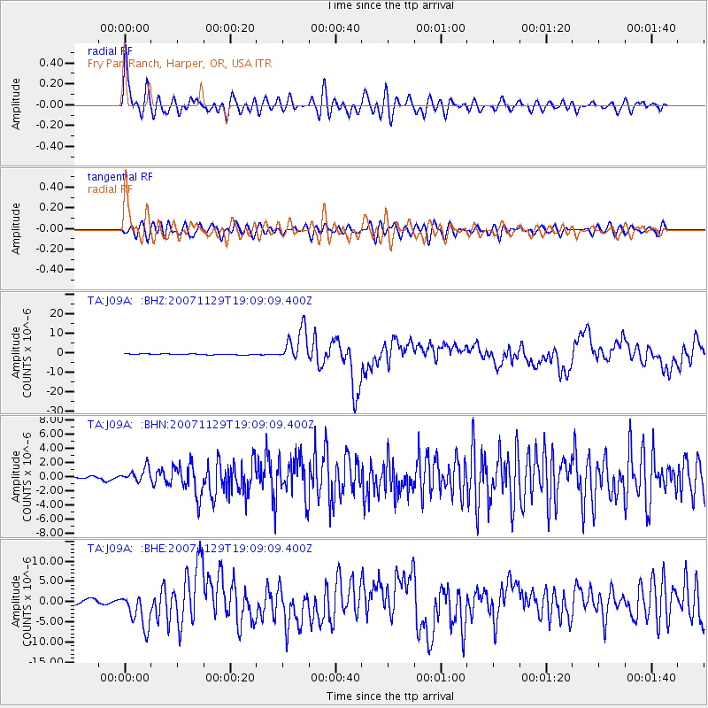
Signal To Noise
| Channel | StoN | STA | LTA |
| TA:J09A: :BHN:20071129T19:09:09.400Z | 5.1471996 | 9.9928E-7 | 1.9414053E-7 |
| TA:J09A: :BHE:20071129T19:09:09.400Z | 9.769465 | 4.406036E-6 | 4.5100072E-7 |
| TA:J09A: :BHZ:20071129T19:09:09.400Z | 35.45477 | 8.624474E-6 | 2.4325286E-7 |
| Arrivals |
| Ps | 4.3 SECOND |
| PpPs | 14 SECOND |
| PsPs/PpSs | 18 SECOND |


