You are here: Home > Network List > TA - USArray Transportable Network (new EarthScope stations) Stations List
> Station J09A Fry Pan Ranch, Harper, OR, USA > Earthquake Result Viewer
J09A Fry Pan Ranch, Harper, OR, USA - Earthquake Result Viewer

| Earthquake location: |
Mariana Islands |
| Earthquake latitude/longitude: |
18.9/145.4 |
| Earthquake time(UTC): |
2007/10/31 (304) 03:30:17 GMT |
| Earthquake Depth: |
223 km |
| Earthquake Magnitude: |
6.2 MB, 7.2 MW, 7.2 MW |
| Earthquake Catalog/Contributor: |
WHDF/NEIC |
|
| Network: |
TA USArray Transportable Network (new EarthScope stations) |
| Station: |
J09A Fry Pan Ranch, Harper, OR, USA |
| Lat/Lon: |
43.35 N/117.75 W |
| Elevation: |
1303 m |
|
| Distance: |
82.1 deg |
| Az: |
46.986 deg |
| Baz: |
288.387 deg |
| Ray Param: |
0.04657002 |
| Estimated Moho Depth: |
19.25 km |
| Estimated Crust Vp/Vs: |
1.68 |
| Assumed Crust Vp: |
6.291 km/s |
| Estimated Crust Vs: |
3.756 km/s |
| Estimated Crust Poisson's Ratio: |
0.22 |
|
| Radial Match: |
88.94313 % |
| Radial Bump: |
400 |
| Transverse Match: |
74.608795 % |
| Transverse Bump: |
400 |
| SOD ConfigId: |
2564 |
| Insert Time: |
2010-03-06 03:13:26.750 +0000 |
| GWidth: |
2.5 |
| Max Bumps: |
400 |
| Tol: |
0.001 |
|
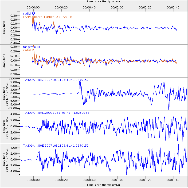
Signal To Noise
| Channel | StoN | STA | LTA |
| TA:J09A: :BHN:20071031T03:41:41.925015Z | 2.023125 | 6.636156E-7 | 3.2801512E-7 |
| TA:J09A: :BHE:20071031T03:41:41.925015Z | 3.769731 | 1.2355472E-6 | 3.2775472E-7 |
| TA:J09A: :BHZ:20071031T03:41:41.925015Z | 14.6527 | 4.343604E-6 | 2.964371E-7 |
| Arrivals |
| Ps | 2.1 SECOND |
| PpPs | 8.0 SECOND |
| PsPs/PpSs | 10 SECOND |


