You are here: Home > Network List > TA - USArray Transportable Network (new EarthScope stations) Stations List
> Station C16K Lisburne Hills, AK, USA > Earthquake Result Viewer
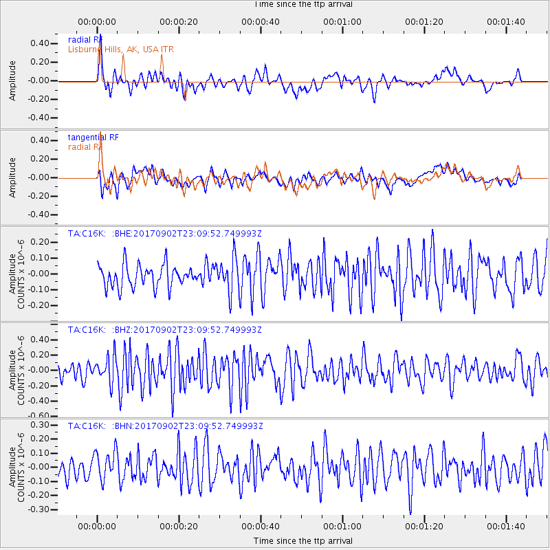
C16K Lisburne Hills, AK, USA - Earthquake Result Viewer
*The percent match for this event was below the threshold and hence no stack was calculated.
| Earthquake location: |
Mariana Islands |
| Earthquake latitude/longitude: |
14.0/146.7 |
| Earthquake time(UTC): |
2017/09/02 (245) 23:00:01 GMT |
| Earthquake Depth: |
10 km |
| Earthquake Magnitude: |
5.5 mb |
| Earthquake Catalog/Contributor: |
NEIC PDE/us |
|
| Network: |
TA USArray Transportable Network (new EarthScope stations) |
| Station: |
C16K Lisburne Hills, AK, USA |
| Lat/Lon: |
68.27 N/165.34 W |
| Elevation: |
102 m |
|
| Distance: |
62.3 deg |
| Az: |
18.209 deg |
| Baz: |
234.552 deg |
| Ray Param: |
$rayparam |
*The percent match for this event was below the threshold and hence was not used in the summary stack. |
|
| Radial Match: |
63.554756 % |
| Radial Bump: |
400 |
| Transverse Match: |
59.52104 % |
| Transverse Bump: |
400 |
| SOD ConfigId: |
13570011 |
| Insert Time: |
2019-04-28 16:24:11.122 +0000 |
| GWidth: |
2.5 |
| Max Bumps: |
400 |
| Tol: |
0.001 |
|
Signal To Noise
| Channel | StoN | STA | LTA |
| TA:C16K: :BHZ:20170902T23:09:52.749993Z | 2.030325 | 1.641771E-7 | 8.086247E-8 |
| TA:C16K: :BHN:20170902T23:09:52.749993Z | 1.2397057 | 1.0694894E-7 | 8.6269615E-8 |
| TA:C16K: :BHE:20170902T23:09:52.749993Z | 1.5965554 | 1.09747084E-7 | 6.8739915E-8 |
| Arrivals |
| Ps | |
| PpPs | |
| PsPs/PpSs | |


