You are here: Home > Network List > II - Global Seismograph Network (GSN - IRIS/IDA) Stations List
> Station WRAB Tennant Creek, NT, Australia > Earthquake Result Viewer
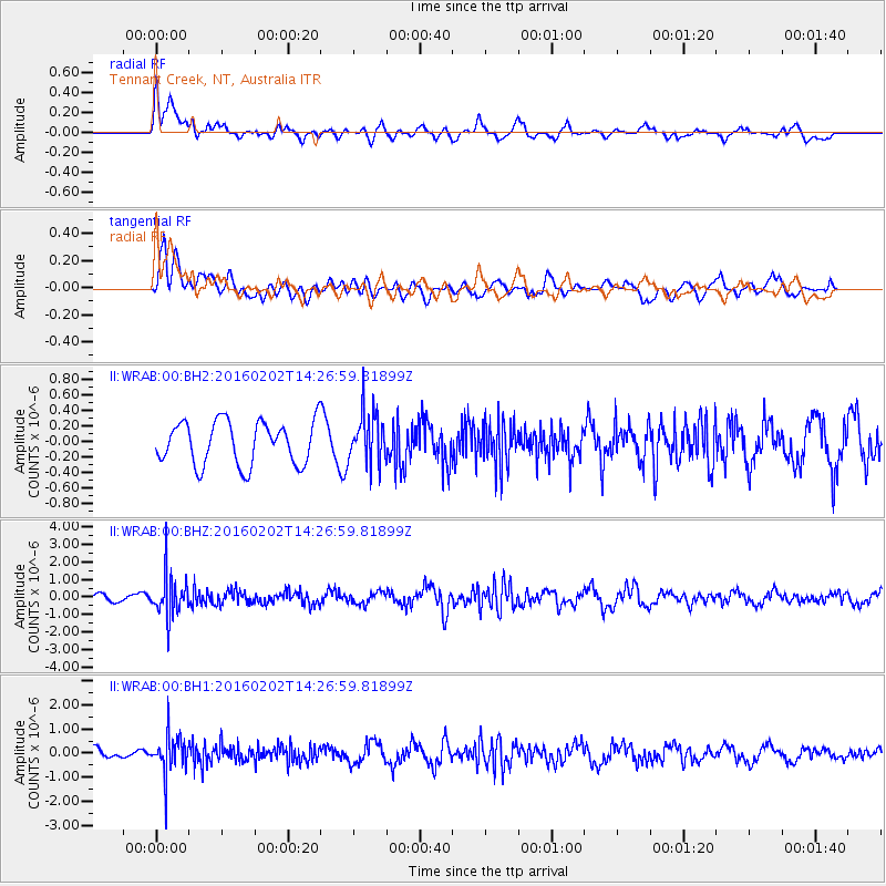
WRAB Tennant Creek, NT, Australia - Earthquake Result Viewer
*The percent match for this event was below the threshold and hence no stack was calculated.
| Earthquake location: |
Northeast Of Taiwan |
| Earthquake latitude/longitude: |
25.6/123.5 |
| Earthquake time(UTC): |
2016/02/02 (033) 14:19:22 GMT |
| Earthquake Depth: |
188 km |
| Earthquake Magnitude: |
5.8 MB, 5.7 MWB |
| Earthquake Catalog/Contributor: |
NEIC PDE/NEIC COMCAT |
|
| Network: |
II Global Seismograph Network (GSN - IRIS/IDA) |
| Station: |
WRAB Tennant Creek, NT, Australia |
| Lat/Lon: |
19.93 S/134.36 E |
| Elevation: |
366 m |
|
| Distance: |
46.5 deg |
| Az: |
165.804 deg |
| Baz: |
346.385 deg |
| Ray Param: |
$rayparam |
*The percent match for this event was below the threshold and hence was not used in the summary stack. |
|
| Radial Match: |
71.13456 % |
| Radial Bump: |
400 |
| Transverse Match: |
70.01352 % |
| Transverse Bump: |
400 |
| SOD ConfigId: |
1427151 |
| Insert Time: |
2016-02-16 14:35:12.692 +0000 |
| GWidth: |
2.5 |
| Max Bumps: |
400 |
| Tol: |
0.001 |
|
Signal To Noise
| Channel | StoN | STA | LTA |
| II:WRAB:00:BHZ:20160202T14:26:59.81899Z | 5.801379 | 1.1680611E-6 | 2.0134198E-7 |
| II:WRAB:00:BH1:20160202T14:26:59.81899Z | 5.873602 | 7.99624E-7 | 1.3613861E-7 |
| II:WRAB:00:BH2:20160202T14:26:59.81899Z | 1.2008053 | 3.3095967E-7 | 2.7561475E-7 |
| Arrivals |
| Ps | |
| PpPs | |
| PsPs/PpSs | |


