You are here: Home > Network List > TA - USArray Transportable Network (new EarthScope stations) Stations List
> Station E23K Chandalar, AK, USA > Earthquake Result Viewer
E23K Chandalar, AK, USA - Earthquake Result Viewer
| Earthquake location: |
Mariana Islands |
| Earthquake latitude/longitude: |
14.0/146.7 |
| Earthquake time(UTC): |
2017/09/02 (245) 23:00:01 GMT |
| Earthquake Depth: |
10 km |
| Earthquake Magnitude: |
5.5 mb |
| Earthquake Catalog/Contributor: |
NEIC PDE/us |
|
| Network: |
TA USArray Transportable Network (new EarthScope stations) |
| Station: |
E23K Chandalar, AK, USA |
| Lat/Lon: |
68.06 N/149.62 W |
| Elevation: |
1084 m |
|
| Distance: |
67.4 deg |
| Az: |
21.409 deg |
| Baz: |
250.513 deg |
| Ray Param: |
0.056992378 |
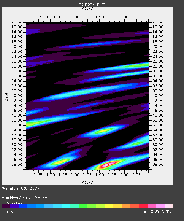
| Estimated Moho Depth: |
67.75 km |
| Estimated Crust Vp/Vs: |
1.93 |
| Assumed Crust Vp: |
6.316 km/s |
| Estimated Crust Vs: |
3.264 km/s |
| Estimated Crust Poisson's Ratio: |
0.32 |
|
| Radial Match: |
86.72877 % |
| Radial Bump: |
400 |
| Transverse Match: |
81.53662 % |
| Transverse Bump: |
400 |
| SOD ConfigId: |
13570011 |
| Insert Time: |
2019-04-28 16:24:21.993 +0000 |
| GWidth: |
2.5 |
| Max Bumps: |
400 |
| Tol: |
0.001 |
|

Signal To Noise
| Channel | StoN | STA | LTA |
| TA:E23K: :BHZ:20170902T23:10:25.975029Z | 2.5091758 | 1.6083564E-7 | 6.409899E-8 |
| TA:E23K: :BHN:20170902T23:10:25.975029Z | 1.2659961 | 6.067087E-8 | 4.7923425E-8 |
| TA:E23K: :BHE:20170902T23:10:25.975029Z | 1.428511 | 8.596652E-8 | 6.0179104E-8 |
| Arrivals |
| Ps | 10 SECOND |
| PpPs | 30 SECOND |
| PsPs/PpSs | 41 SECOND |


