You are here: Home > Network List > TA - USArray Transportable Network (new EarthScope stations) Stations List
> Station H31M Peel River, Yukon, CAN > Earthquake Result Viewer
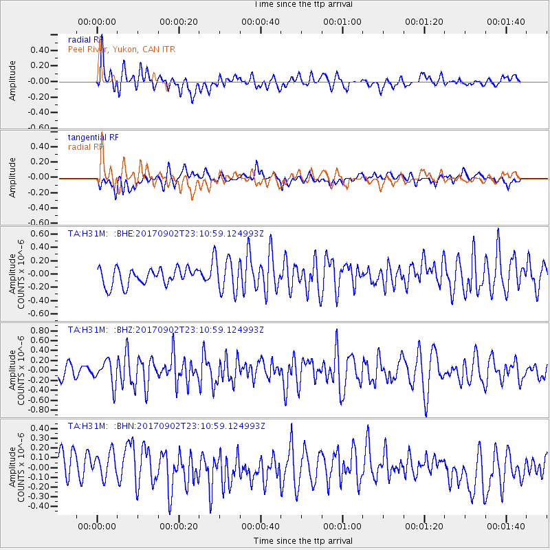
H31M Peel River, Yukon, CAN - Earthquake Result Viewer
*The percent match for this event was below the threshold and hence no stack was calculated.
| Earthquake location: |
Mariana Islands |
| Earthquake latitude/longitude: |
14.0/146.7 |
| Earthquake time(UTC): |
2017/09/02 (245) 23:00:01 GMT |
| Earthquake Depth: |
10 km |
| Earthquake Magnitude: |
5.5 mb |
| Earthquake Catalog/Contributor: |
NEIC PDE/us |
|
| Network: |
TA USArray Transportable Network (new EarthScope stations) |
| Station: |
H31M Peel River, Yukon, CAN |
| Lat/Lon: |
65.81 N/134.34 W |
| Elevation: |
642 m |
|
| Distance: |
72.8 deg |
| Az: |
25.054 deg |
| Baz: |
265.81 deg |
| Ray Param: |
$rayparam |
*The percent match for this event was below the threshold and hence was not used in the summary stack. |
|
| Radial Match: |
63.16541 % |
| Radial Bump: |
400 |
| Transverse Match: |
44.57133 % |
| Transverse Bump: |
400 |
| SOD ConfigId: |
13570011 |
| Insert Time: |
2019-04-28 16:24:35.932 +0000 |
| GWidth: |
2.5 |
| Max Bumps: |
400 |
| Tol: |
0.001 |
|
Signal To Noise
| Channel | StoN | STA | LTA |
| TA:H31M: :BHZ:20170902T23:10:59.124993Z | 2.0493162 | 2.4582266E-7 | 1.1995351E-7 |
| TA:H31M: :BHN:20170902T23:10:59.124993Z | 0.8970951 | 1.5718787E-7 | 1.7521873E-7 |
| TA:H31M: :BHE:20170902T23:10:59.124993Z | 2.2196186 | 2.790028E-7 | 1.2569853E-7 |
| Arrivals |
| Ps | |
| PpPs | |
| PsPs/PpSs | |


