You are here: Home > Network List > TA - USArray Transportable Network (new EarthScope stations) Stations List
> Station J20K Nowitna River, AK, USA > Earthquake Result Viewer
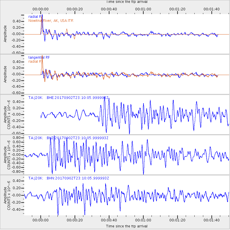
J20K Nowitna River, AK, USA - Earthquake Result Viewer

| Earthquake location: |
Mariana Islands |
| Earthquake latitude/longitude: |
14.0/146.7 |
| Earthquake time(UTC): |
2017/09/02 (245) 23:00:01 GMT |
| Earthquake Depth: |
10 km |
| Earthquake Magnitude: |
5.5 mb |
| Earthquake Catalog/Contributor: |
NEIC PDE/us |
|
| Network: |
TA USArray Transportable Network (new EarthScope stations) |
| Station: |
J20K Nowitna River, AK, USA |
| Lat/Lon: |
64.18 N/154.15 W |
| Elevation: |
314 m |
|
| Distance: |
64.3 deg |
| Az: |
24.678 deg |
| Baz: |
247.712 deg |
| Ray Param: |
0.05902974 |
| Estimated Moho Depth: |
18.25 km |
| Estimated Crust Vp/Vs: |
1.89 |
| Assumed Crust Vp: |
6.566 km/s |
| Estimated Crust Vs: |
3.47 km/s |
| Estimated Crust Poisson's Ratio: |
0.31 |
|
| Radial Match: |
88.63889 % |
| Radial Bump: |
390 |
| Transverse Match: |
73.88843 % |
| Transverse Bump: |
400 |
| SOD ConfigId: |
13570011 |
| Insert Time: |
2019-04-28 16:24:40.405 +0000 |
| GWidth: |
2.5 |
| Max Bumps: |
400 |
| Tol: |
0.001 |
|
Signal To Noise
| Channel | StoN | STA | LTA |
| TA:J20K: :BHZ:20170902T23:10:05.999993Z | 2.20267 | 1.4959325E-7 | 6.7914506E-8 |
| TA:J20K: :BHN:20170902T23:10:05.999993Z | 1.1565605 | 7.245081E-8 | 6.264334E-8 |
| TA:J20K: :BHE:20170902T23:10:05.999993Z | 0.921288 | 6.1237415E-8 | 6.646935E-8 |
| Arrivals |
| Ps | 2.6 SECOND |
| PpPs | 7.7 SECOND |
| PsPs/PpSs | 10 SECOND |


