You are here: Home > Network List > TA - USArray Transportable Network (new EarthScope stations) Stations List
> Station J09A Fry Pan Ranch, Harper, OR, USA > Earthquake Result Viewer
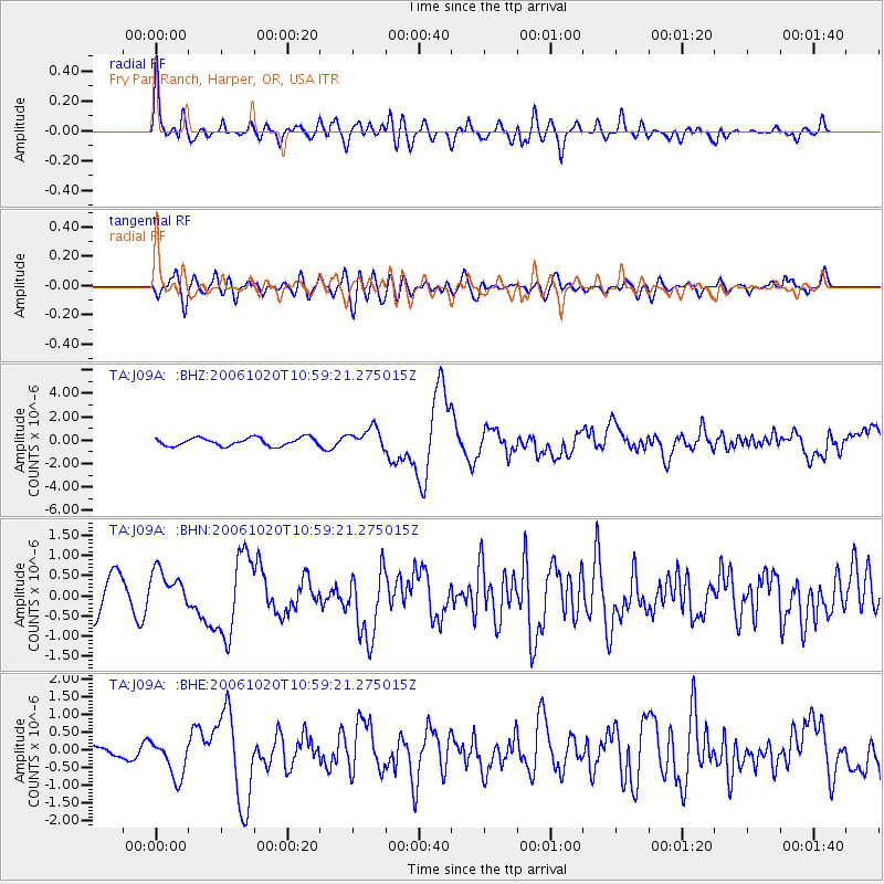
J09A Fry Pan Ranch, Harper, OR, USA - Earthquake Result Viewer
| Earthquake location: |
Near Coast Of Peru |
| Earthquake latitude/longitude: |
-13.5/-76.7 |
| Earthquake time(UTC): |
2006/10/20 (293) 10:48:56 GMT |
| Earthquake Depth: |
23 km |
| Earthquake Magnitude: |
5.9 MB, 6.6 MS, 6.7 MW, 6.6 MW |
| Earthquake Catalog/Contributor: |
WHDF/NEIC |
|
| Network: |
TA USArray Transportable Network (new EarthScope stations) |
| Station: |
J09A Fry Pan Ranch, Harper, OR, USA |
| Lat/Lon: |
43.35 N/117.75 W |
| Elevation: |
1303 m |
|
| Distance: |
67.9 deg |
| Az: |
328.836 deg |
| Baz: |
136.358 deg |
| Ray Param: |
0.05665306 |
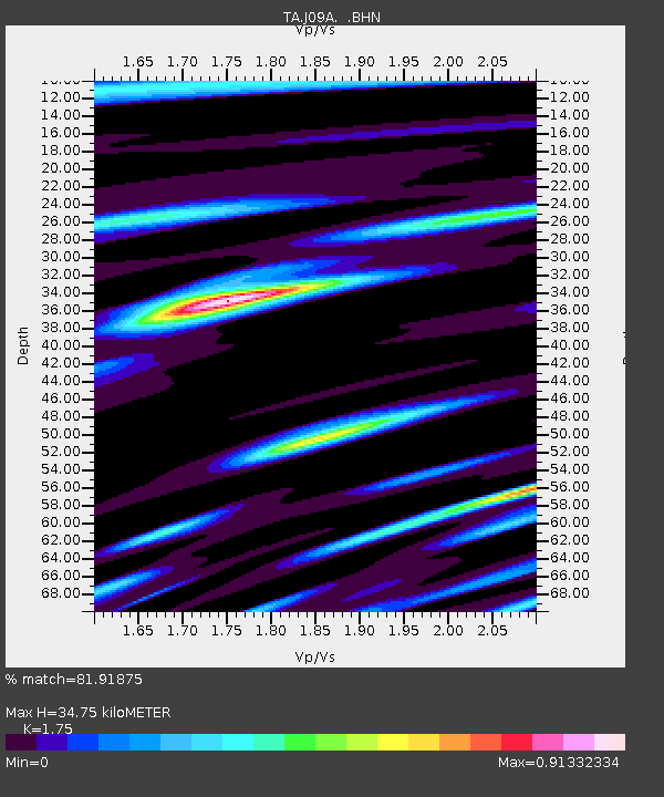
| Estimated Moho Depth: |
34.75 km |
| Estimated Crust Vp/Vs: |
1.75 |
| Assumed Crust Vp: |
6.291 km/s |
| Estimated Crust Vs: |
3.595 km/s |
| Estimated Crust Poisson's Ratio: |
0.26 |
|
| Radial Match: |
81.91875 % |
| Radial Bump: |
400 |
| Transverse Match: |
71.73557 % |
| Transverse Bump: |
400 |
| SOD ConfigId: |
2564 |
| Insert Time: |
2010-03-06 03:14:24.439 +0000 |
| GWidth: |
2.5 |
| Max Bumps: |
400 |
| Tol: |
0.001 |
|
Signal To Noise
| Channel | StoN | STA | LTA |
| TA:J09A: :BHN:20061020T10:59:21.275015Z | 1.2338014 | 4.952207E-7 | 4.0137797E-7 |
| TA:J09A: :BHE:20061020T10:59:21.275015Z | 1.9803592 | 5.4211716E-7 | 2.7374688E-7 |
| TA:J09A: :BHZ:20061020T10:59:21.275015Z | 2.5994418 | 8.9637393E-7 | 3.4483324E-7 |
| Arrivals |
| Ps | 4.3 SECOND |
| PpPs | 15 SECOND |
| PsPs/PpSs | 19 SECOND |


