You are here: Home > Network List > TA - USArray Transportable Network (new EarthScope stations) Stations List
> Station J09A Fry Pan Ranch, Harper, OR, USA > Earthquake Result Viewer
J09A Fry Pan Ranch, Harper, OR, USA - Earthquake Result Viewer
| Earthquake location: |
Chile-Argentina Border Region |
| Earthquake latitude/longitude: |
-24.4/-67.0 |
| Earthquake time(UTC): |
2006/08/25 (237) 00:44:46 GMT |
| Earthquake Depth: |
184 km |
| Earthquake Magnitude: |
5.9 MB, 6.6 MW, 6.6 MW |
| Earthquake Catalog/Contributor: |
WHDF/NEIC |
|
| Network: |
TA USArray Transportable Network (new EarthScope stations) |
| Station: |
J09A Fry Pan Ranch, Harper, OR, USA |
| Lat/Lon: |
43.35 N/117.75 W |
| Elevation: |
1303 m |
|
| Distance: |
82.0 deg |
| Az: |
325.226 deg |
| Baz: |
134.538 deg |
| Ray Param: |
0.046780255 |
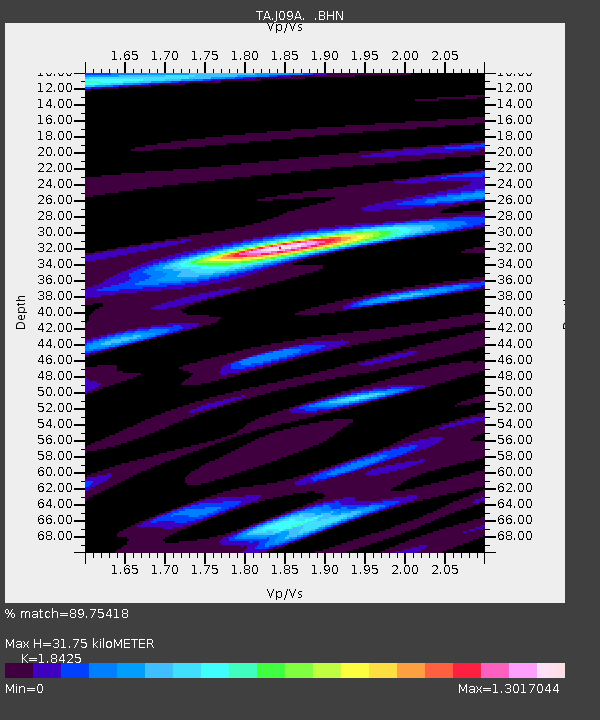
| Estimated Moho Depth: |
31.75 km |
| Estimated Crust Vp/Vs: |
1.84 |
| Assumed Crust Vp: |
6.291 km/s |
| Estimated Crust Vs: |
3.415 km/s |
| Estimated Crust Poisson's Ratio: |
0.29 |
|
| Radial Match: |
89.75418 % |
| Radial Bump: |
400 |
| Transverse Match: |
77.484825 % |
| Transverse Bump: |
400 |
| SOD ConfigId: |
2564 |
| Insert Time: |
2010-03-06 03:14:29.246 +0000 |
| GWidth: |
2.5 |
| Max Bumps: |
400 |
| Tol: |
0.001 |
|

Signal To Noise
| Channel | StoN | STA | LTA |
| TA:J09A: :BHN:20060825T00:56:14.125007Z | 7.1424665 | 5.105839E-7 | 7.148566E-8 |
| TA:J09A: :BHE:20060825T00:56:14.125007Z | 7.767987 | 6.3152953E-7 | 8.129899E-8 |
| TA:J09A: :BHZ:20060825T00:56:14.125007Z | 32.47854 | 1.8496199E-6 | 5.6948988E-8 |
| Arrivals |
| Ps | 4.4 SECOND |
| PpPs | 14 SECOND |
| PsPs/PpSs | 18 SECOND |


