You are here: Home > Network List > TA - USArray Transportable Network (new EarthScope stations) Stations List
> Station J09A Fry Pan Ranch, Harper, OR, USA > Earthquake Result Viewer
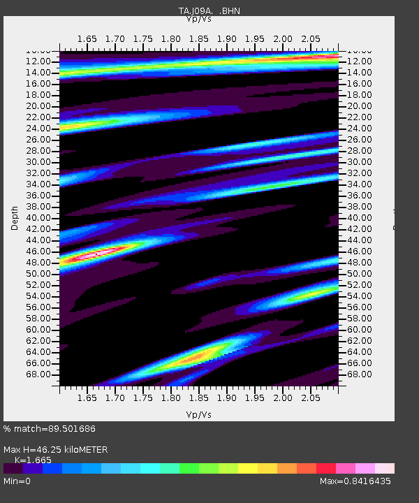
J09A Fry Pan Ranch, Harper, OR, USA - Earthquake Result Viewer
| Earthquake location: |
Kuril Islands |
| Earthquake latitude/longitude: |
46.5/153.2 |
| Earthquake time(UTC): |
2006/10/01 (274) 09:06:02 GMT |
| Earthquake Depth: |
19 km |
| Earthquake Magnitude: |
6.1 MB, 6.4 MS, 6.6 MW, 6.5 MW |
| Earthquake Catalog/Contributor: |
WHDF/NEIC |
|
| Network: |
TA USArray Transportable Network (new EarthScope stations) |
| Station: |
J09A Fry Pan Ranch, Harper, OR, USA |
| Lat/Lon: |
43.35 N/117.75 W |
| Elevation: |
1303 m |
|
| Distance: |
59.8 deg |
| Az: |
57.561 deg |
| Baz: |
306.908 deg |
| Ray Param: |
0.061931808 |
| Estimated Moho Depth: |
46.25 km |
| Estimated Crust Vp/Vs: |
1.66 |
| Assumed Crust Vp: |
6.291 km/s |
| Estimated Crust Vs: |
3.779 km/s |
| Estimated Crust Poisson's Ratio: |
0.22 |
|
| Radial Match: |
89.501686 % |
| Radial Bump: |
400 |
| Transverse Match: |
73.90286 % |
| Transverse Bump: |
400 |
| SOD ConfigId: |
2665 |
| Insert Time: |
2010-03-06 03:14:36.727 +0000 |
| GWidth: |
2.5 |
| Max Bumps: |
400 |
| Tol: |
0.001 |
|

Signal To Noise
| Channel | StoN | STA | LTA |
| TA:J09A: :BHN:20061001T09:15:35.124016Z | 1.0250838 | 3.435627E-7 | 3.3515576E-7 |
| TA:J09A: :BHE:20061001T09:15:35.124016Z | 1.8023365 | 3.8314158E-7 | 2.1258049E-7 |
| TA:J09A: :BHZ:20061001T09:15:35.124016Z | 2.5922732 | 6.556146E-7 | 2.5291106E-7 |
| Arrivals |
| Ps | 5.1 SECOND |
| PpPs | 19 SECOND |
| PsPs/PpSs | 24 SECOND |


