You are here: Home > Network List > TA - USArray Transportable Network (new EarthScope stations) Stations List
> Station M03C McCloud, CA, USA > Earthquake Result Viewer
M03C McCloud, CA, USA - Earthquake Result Viewer
| Earthquake location: |
Fiji Islands Region |
| Earthquake latitude/longitude: |
-15.3/-178.6 |
| Earthquake time(UTC): |
2005/12/13 (347) 03:16:06 GMT |
| Earthquake Depth: |
10 km |
| Earthquake Magnitude: |
6.1 MB, 6.8 MS, 6.7 MW, 6.7 MW |
| Earthquake Catalog/Contributor: |
WHDF/NEIC |
|
| Network: |
TA USArray Transportable Network (new EarthScope stations) |
| Station: |
M03C McCloud, CA, USA |
| Lat/Lon: |
41.27 N/122.12 W |
| Elevation: |
1047 m |
|
| Distance: |
76.7 deg |
| Az: |
40.203 deg |
| Baz: |
235.746 deg |
| Ray Param: |
0.05082148 |
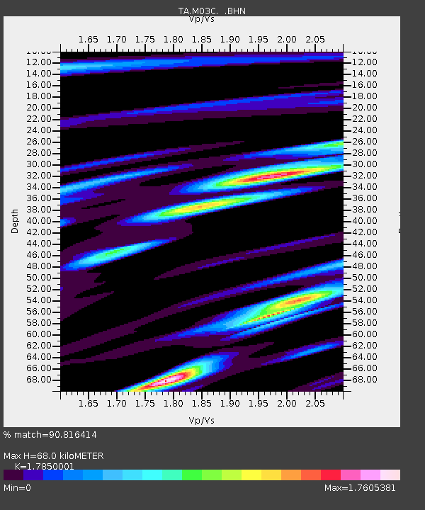
| Estimated Moho Depth: |
68.0 km |
| Estimated Crust Vp/Vs: |
1.79 |
| Assumed Crust Vp: |
6.566 km/s |
| Estimated Crust Vs: |
3.679 km/s |
| Estimated Crust Poisson's Ratio: |
0.27 |
|
| Radial Match: |
90.816414 % |
| Radial Bump: |
400 |
| Transverse Match: |
80.86243 % |
| Transverse Bump: |
400 |
| SOD ConfigId: |
2564 |
| Insert Time: |
2010-03-06 03:14:47.796 +0000 |
| GWidth: |
2.5 |
| Max Bumps: |
400 |
| Tol: |
0.001 |
|

Signal To Noise
| Channel | StoN | STA | LTA |
| TA:M03C: :BHN:20051213T03:27:26.200007Z | 2.5463884 | 4.520352E-7 | 1.7752014E-7 |
| TA:M03C: :BHE:20051213T03:27:26.200007Z | 2.0425456 | 4.8637077E-7 | 2.3811991E-7 |
| TA:M03C: :BHZ:20051213T03:27:26.200007Z | 5.140026 | 1.2271962E-6 | 2.387529E-7 |
| Arrivals |
| Ps | 8.4 SECOND |
| PpPs | 28 SECOND |
| PsPs/PpSs | 36 SECOND |


