You are here: Home > Network List > TA - USArray Transportable Network (new EarthScope stations) Stations List
> Station M03C McCloud, CA, USA > Earthquake Result Viewer
M03C McCloud, CA, USA - Earthquake Result Viewer

| Earthquake location: |
Southeast Of Loyalty Islands |
| Earthquake latitude/longitude: |
-21.2/169.4 |
| Earthquake time(UTC): |
2007/09/28 (271) 01:01:48 GMT |
| Earthquake Depth: |
10 km |
| Earthquake Magnitude: |
5.8 MB, 6.4 MS, 6.3 MW, 6.2 MW |
| Earthquake Catalog/Contributor: |
WHDF/NEIC |
|
| Network: |
TA USArray Transportable Network (new EarthScope stations) |
| Station: |
M03C McCloud, CA, USA |
| Lat/Lon: |
41.27 N/122.12 W |
| Elevation: |
1047 m |
|
| Distance: |
88.8 deg |
| Az: |
44.551 deg |
| Baz: |
240.282 deg |
| Ray Param: |
0.04233031 |
| Estimated Moho Depth: |
18.75 km |
| Estimated Crust Vp/Vs: |
2.07 |
| Assumed Crust Vp: |
6.566 km/s |
| Estimated Crust Vs: |
3.172 km/s |
| Estimated Crust Poisson's Ratio: |
0.35 |
|
| Radial Match: |
83.0333 % |
| Radial Bump: |
400 |
| Transverse Match: |
84.46348 % |
| Transverse Bump: |
400 |
| SOD ConfigId: |
2564 |
| Insert Time: |
2010-03-06 03:15:07.947 +0000 |
| GWidth: |
2.5 |
| Max Bumps: |
400 |
| Tol: |
0.001 |
|
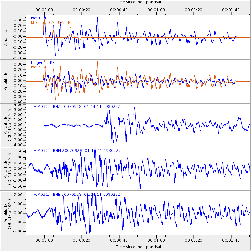
Signal To Noise
| Channel | StoN | STA | LTA |
| TA:M03C: :BHN:20070928T01:14:11.198022Z | 1.2005435 | 2.6775103E-7 | 2.2302484E-7 |
| TA:M03C: :BHE:20070928T01:14:11.198022Z | 1.9169053 | 3.8579114E-7 | 2.0125728E-7 |
| TA:M03C: :BHZ:20070928T01:14:11.198022Z | 4.7925277 | 8.365386E-7 | 1.7455062E-7 |
| Arrivals |
| Ps | 3.1 SECOND |
| PpPs | 8.6 SECOND |
| PsPs/PpSs | 12 SECOND |


