You are here: Home > Network List > TA - USArray Transportable Network (new EarthScope stations) Stations List
> Station M03C McCloud, CA, USA > Earthquake Result Viewer
M03C McCloud, CA, USA - Earthquake Result Viewer

| Earthquake location: |
Kuril Islands |
| Earthquake latitude/longitude: |
45.8/150.1 |
| Earthquake time(UTC): |
2007/09/03 (246) 16:14:53 GMT |
| Earthquake Depth: |
94 km |
| Earthquake Magnitude: |
6.3 MB, 6.2 MW, 6.2 ME |
| Earthquake Catalog/Contributor: |
WHDF/NEIC |
|
| Network: |
TA USArray Transportable Network (new EarthScope stations) |
| Station: |
M03C McCloud, CA, USA |
| Lat/Lon: |
41.27 N/122.12 W |
| Elevation: |
1047 m |
|
| Distance: |
60.7 deg |
| Az: |
59.77 deg |
| Baz: |
306.738 deg |
| Ray Param: |
0.06111877 |
| Estimated Moho Depth: |
42.5 km |
| Estimated Crust Vp/Vs: |
1.70 |
| Assumed Crust Vp: |
6.566 km/s |
| Estimated Crust Vs: |
3.874 km/s |
| Estimated Crust Poisson's Ratio: |
0.23 |
|
| Radial Match: |
83.777756 % |
| Radial Bump: |
400 |
| Transverse Match: |
85.890945 % |
| Transverse Bump: |
400 |
| SOD ConfigId: |
2564 |
| Insert Time: |
2010-03-06 03:15:14.316 +0000 |
| GWidth: |
2.5 |
| Max Bumps: |
400 |
| Tol: |
0.001 |
|
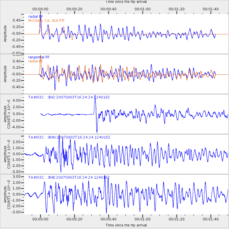
Signal To Noise
| Channel | StoN | STA | LTA |
| TA:M03C: :BHN:20070903T16:24:24.124016Z | 5.435892 | 5.79239E-7 | 1.06558225E-7 |
| TA:M03C: :BHE:20070903T16:24:24.124016Z | 5.2264824 | 1.2495451E-6 | 2.3907955E-7 |
| TA:M03C: :BHZ:20070903T16:24:24.124016Z | 20.44506 | 2.4886676E-6 | 1.2172464E-7 |
| Arrivals |
| Ps | 4.7 SECOND |
| PpPs | 17 SECOND |
| PsPs/PpSs | 21 SECOND |


