You are here: Home > Network List > CN - Canadian National Seismograph Network Stations List
> Station INK INUVIK, NT > Earthquake Result Viewer
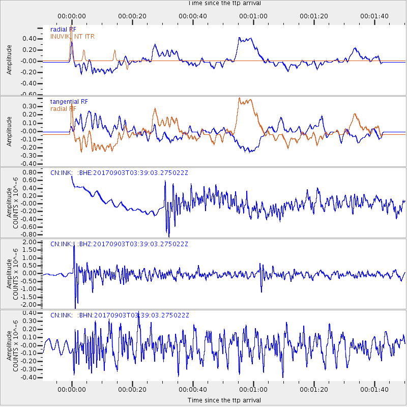
INK INUVIK, NT - Earthquake Result Viewer
*The percent match for this event was below the threshold and hence no stack was calculated.
| Earthquake location: |
North Korea |
| Earthquake latitude/longitude: |
41.3/129.0 |
| Earthquake time(UTC): |
2017/09/03 (246) 03:30:01 GMT |
| Earthquake Depth: |
0.0 km |
| Earthquake Magnitude: |
6.3 mb |
| Earthquake Catalog/Contributor: |
NEIC PDE/us |
|
| Network: |
CN Canadian National Seismograph Network |
| Station: |
INK INUVIK, NT |
| Lat/Lon: |
68.31 N/133.53 W |
| Elevation: |
44 m |
|
| Distance: |
54.9 deg |
| Az: |
26.773 deg |
| Baz: |
294.175 deg |
| Ray Param: |
$rayparam |
*The percent match for this event was below the threshold and hence was not used in the summary stack. |
|
| Radial Match: |
31.522875 % |
| Radial Bump: |
400 |
| Transverse Match: |
32.519135 % |
| Transverse Bump: |
400 |
| SOD ConfigId: |
13570011 |
| Insert Time: |
2019-04-28 16:33:36.128 +0000 |
| GWidth: |
2.5 |
| Max Bumps: |
400 |
| Tol: |
0.001 |
|
Signal To Noise
| Channel | StoN | STA | LTA |
| CN:INK: :BHZ:20170903T03:39:03.275022Z | 10.998234 | 7.480892E-7 | 6.8019034E-8 |
| CN:INK: :BHN:20170903T03:39:03.275022Z | 1.7070805 | 1.3666099E-7 | 8.0055386E-8 |
| CN:INK: :BHE:20170903T03:39:03.275022Z | 1.6265289 | 3.7928035E-7 | 2.331839E-7 |
| Arrivals |
| Ps | |
| PpPs | |
| PsPs/PpSs | |


