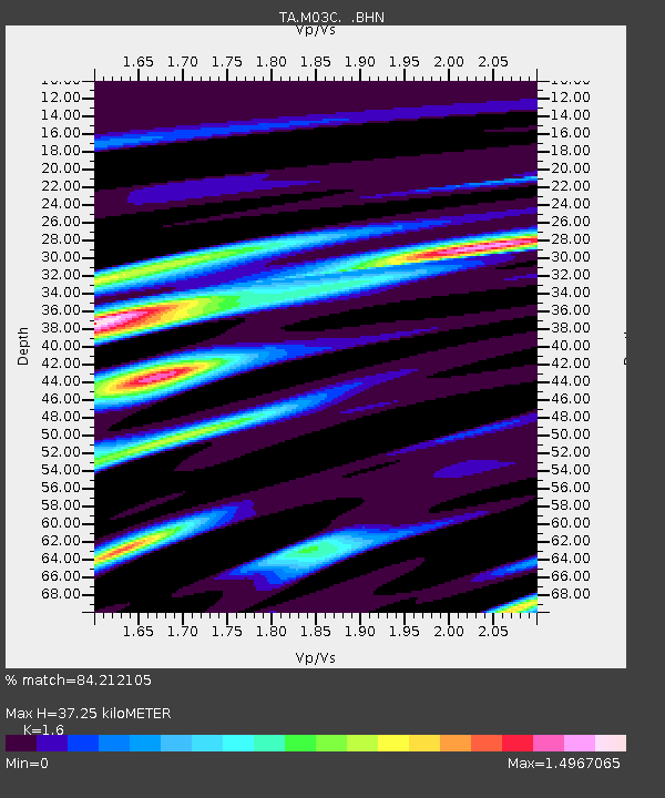
M03C McCloud, CA, USA - Earthquake Result Viewer
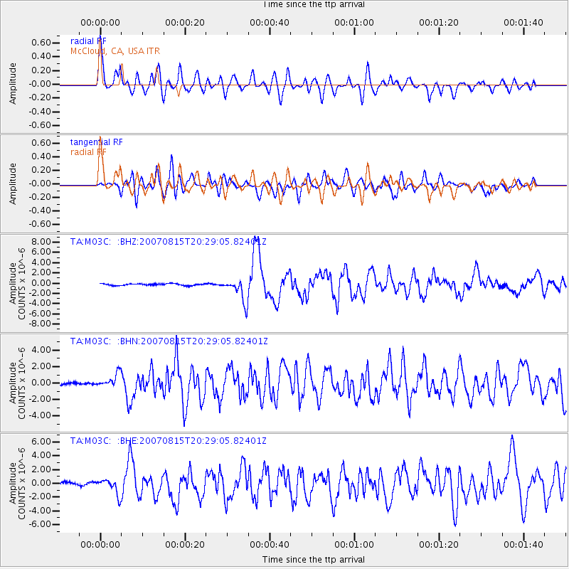
Earthquake location: Andreanof Islands, Aleutian Is.
Earthquake latitude/longitude: 50.3/-177.5
Earthquake time(UTC): 2007/08/15 (227) 20:22:11 GMT
Earthquake Depth: 9.0 km
Earthquake Magnitude: 6.3 MB, 6.2 MS, 6.4 MW, 5.9 ML
Earthquake Catalog/Contributor: WHDF/NEIC
Network: TA USArray Transportable Network (new EarthScope stations)
Station: M03C McCloud, CA, USA
Lat/Lon: 41.27 N/122.12 W
Elevation: 1047 m
Distance: 38.9 deg
Az: 81.483 deg
Baz: 302.749 deg
Ray Param: 0.07531481
Estimated Moho Depth: 37.25 km
Estimated Crust Vp/Vs: 1.60
Assumed Crust Vp: 6.566 km/s
Estimated Crust Vs: 4.104 km/s
Estimated Crust Poisson's Ratio: 0.18
Radial Match: 84.212105 %
Radial Bump: 400
Transverse Match: 76.02611 %
Transverse Bump: 400
SOD ConfigId: 2564
Insert Time: 2010-03-06 03:15:24.101 +0000
GWidth: 2.5
Max Bumps: 400
Tol: 0.001

Signal To Noise

ChannelStoNSTALTA
TA:M03C: :BHN:20070815T20:29:05.82401Z5.87948139.01325E-71.5330009E-7
TA:M03C: :BHE:20070815T20:29:05.82401Z5.35730361.1307327E-62.1106378E-7
TA:M03C: :BHZ:20070815T20:29:05.82401Z13.9416512.364979E-61.6963406E-7
Arrivals
Ps3.7 SECOND
PpPs14 SECOND
PsPs/PpSs17 SECOND