You are here: Home > Network List > TA - USArray Transportable Network (new EarthScope stations) Stations List
> Station M03C McCloud, CA, USA > Earthquake Result Viewer
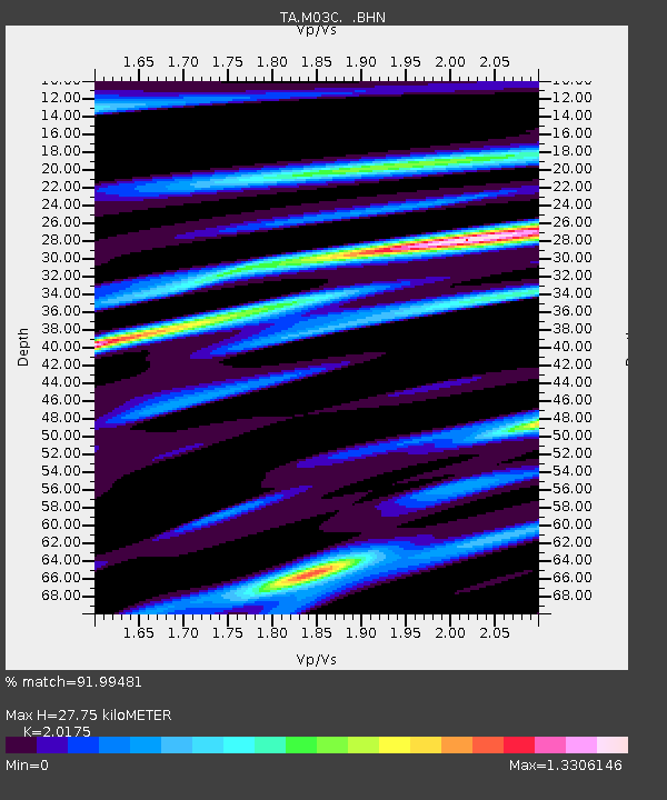
M03C McCloud, CA, USA - Earthquake Result Viewer
| Earthquake location: |
Solomon Islands |
| Earthquake latitude/longitude: |
-8.5/157.0 |
| Earthquake time(UTC): |
2007/04/01 (091) 20:39:56 GMT |
| Earthquake Depth: |
10 km |
| Earthquake Magnitude: |
6.8 MB, 7.9 MS, 8.1 MW, 7.7 ME |
| Earthquake Catalog/Contributor: |
WHDF/NEIC |
|
| Network: |
TA USArray Transportable Network (new EarthScope stations) |
| Station: |
M03C McCloud, CA, USA |
| Lat/Lon: |
41.27 N/122.12 W |
| Elevation: |
1047 m |
|
| Distance: |
88.7 deg |
| Az: |
48.101 deg |
| Baz: |
257.656 deg |
| Ray Param: |
0.04239323 |
| Estimated Moho Depth: |
27.75 km |
| Estimated Crust Vp/Vs: |
2.02 |
| Assumed Crust Vp: |
6.566 km/s |
| Estimated Crust Vs: |
3.255 km/s |
| Estimated Crust Poisson's Ratio: |
0.34 |
|
| Radial Match: |
91.99481 % |
| Radial Bump: |
400 |
| Transverse Match: |
92.41442 % |
| Transverse Bump: |
400 |
| SOD ConfigId: |
2564 |
| Insert Time: |
2010-03-06 03:15:46.863 +0000 |
| GWidth: |
2.5 |
| Max Bumps: |
400 |
| Tol: |
0.001 |
|

Signal To Noise
| Channel | StoN | STA | LTA |
| TA:M03C: :BHN:20070401T20:52:18.325007Z | 1.551222 | 2.0947601E-7 | 1.3503936E-7 |
| TA:M03C: :BHE:20070401T20:52:18.325007Z | 4.71467 | 6.3183006E-7 | 1.3401362E-7 |
| TA:M03C: :BHZ:20070401T20:52:18.325007Z | 11.31304 | 1.7887625E-6 | 1.581151E-7 |
| Arrivals |
| Ps | 4.4 SECOND |
| PpPs | 13 SECOND |
| PsPs/PpSs | 17 SECOND |


