You are here: Home > Network List > TA - USArray Transportable Network (new EarthScope stations) Stations List
> Station M03C McCloud, CA, USA > Earthquake Result Viewer
M03C McCloud, CA, USA - Earthquake Result Viewer
| Earthquake location: |
Tonga Islands |
| Earthquake latitude/longitude: |
-21.3/-174.7 |
| Earthquake time(UTC): |
2006/11/30 (334) 11:33:17 GMT |
| Earthquake Depth: |
14 km |
| Earthquake Magnitude: |
5.7 MB, 6.1 MS, 6.0 MW, 6.0 MW |
| Earthquake Catalog/Contributor: |
WHDF/NEIC |
|
| Network: |
TA USArray Transportable Network (new EarthScope stations) |
| Station: |
M03C McCloud, CA, USA |
| Lat/Lon: |
41.27 N/122.12 W |
| Elevation: |
1047 m |
|
| Distance: |
79.0 deg |
| Az: |
37.557 deg |
| Baz: |
228.948 deg |
| Ray Param: |
0.04922502 |
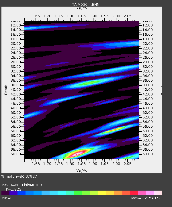
| Estimated Moho Depth: |
68.0 km |
| Estimated Crust Vp/Vs: |
1.83 |
| Assumed Crust Vp: |
6.566 km/s |
| Estimated Crust Vs: |
3.598 km/s |
| Estimated Crust Poisson's Ratio: |
0.29 |
|
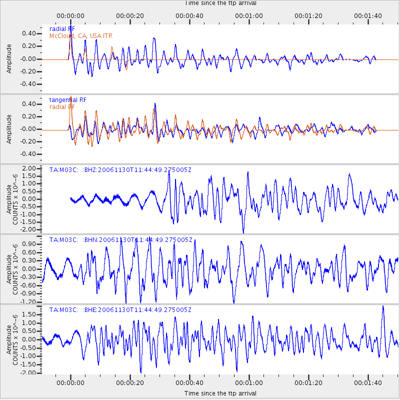
| Radial Match: |
80.67927 % |
| Radial Bump: |
400 |
| Transverse Match: |
68.46371 % |
| Transverse Bump: |
400 |
| SOD ConfigId: |
2564 |
| Insert Time: |
2010-03-06 03:15:59.408 +0000 |
| GWidth: |
2.5 |
| Max Bumps: |
400 |
| Tol: |
0.001 |
|
Signal To Noise
| Channel | StoN | STA | LTA |
| TA:M03C: :BHN:20061130T11:44:49.275005Z | 1.0387135 | 2.69456E-7 | 2.594132E-7 |
| TA:M03C: :BHE:20061130T11:44:49.275005Z | 2.3367243 | 4.998549E-7 | 2.1391264E-7 |
| TA:M03C: :BHZ:20061130T11:44:49.275005Z | 4.177255 | 8.6386854E-7 | 2.0680292E-7 |
| Arrivals |
| Ps | 8.8 SECOND |
| PpPs | 28 SECOND |
| PsPs/PpSs | 37 SECOND |


