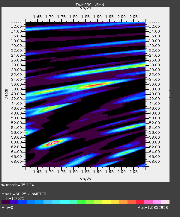
M03C McCloud, CA, USA - Earthquake Result Viewer
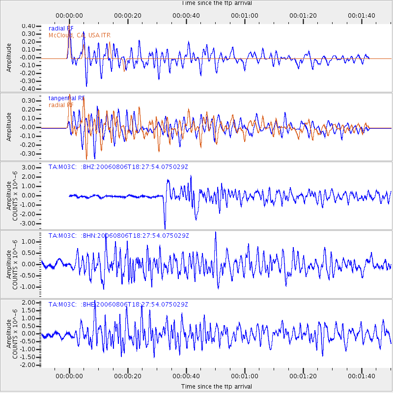
Earthquake location: Bonin Islands, Japan Region
Earthquake latitude/longitude: 26.1/144.0
Earthquake time(UTC): 2006/08/06 (218) 18:16:40 GMT
Earthquake Depth: 23 km
Earthquake Magnitude: 6.0 MB, 5.6 MS, 5.8 MW, 5.8 MW
Earthquake Catalog/Contributor: WHDF/NEIC
Network: TA USArray Transportable Network (new EarthScope stations)
Station: M03C McCloud, CA, USA
Lat/Lon: 41.27 N/122.12 W
Elevation: 1047 m
Distance: 76.0 deg
Az: 50.812 deg
Baz: 292.412 deg
Ray Param: 0.05126724
Estimated Moho Depth: 60.25 km
Estimated Crust Vp/Vs: 1.71
Assumed Crust Vp: 6.566 km/s
Estimated Crust Vs: 3.845 km/s
Estimated Crust Poisson's Ratio: 0.24
Radial Match: 85.124 %
Radial Bump: 400
Transverse Match: 82.11783 %
Transverse Bump: 400
SOD ConfigId: 5423
Insert Time: 2010-03-06 03:16:04.859 +0000
GWidth: 2.5
Max Bumps: 400
Tol: 0.001

Signal To Noise

ChannelStoNSTALTA
TA:M03C: :BHN:20060806T18:27:54.075029Z2.07872272.781682E-71.3381688E-7
TA:M03C: :BHE:20060806T18:27:54.075029Z4.4218533.803998E-78.602724E-8
TA:M03C: :BHZ:20060806T18:27:54.075029Z13.7096771.166292E-68.507072E-8
Arrivals
Ps6.7 SECOND
PpPs24 SECOND
PsPs/PpSs31 SECOND