You are here: Home > Network List > TA - USArray Transportable Network (new EarthScope stations) Stations List
> Station D22K Ayikyak River, AK, USA > Earthquake Result Viewer
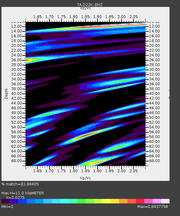
D22K Ayikyak River, AK, USA - Earthquake Result Viewer
| Earthquake location: |
North Korea |
| Earthquake latitude/longitude: |
41.3/129.0 |
| Earthquake time(UTC): |
2017/09/03 (246) 03:30:01 GMT |
| Earthquake Depth: |
0.0 km |
| Earthquake Magnitude: |
6.3 mb |
| Earthquake Catalog/Contributor: |
NEIC PDE/us |
|
| Network: |
TA USArray Transportable Network (new EarthScope stations) |
| Station: |
D22K Ayikyak River, AK, USA |
| Lat/Lon: |
68.88 N/152.68 W |
| Elevation: |
532 m |
|
| Distance: |
48.0 deg |
| Az: |
28.51 deg |
| Baz: |
277.417 deg |
| Ray Param: |
0.06964231 |
| Estimated Moho Depth: |
11.0 km |
| Estimated Crust Vp/Vs: |
2.03 |
| Assumed Crust Vp: |
6.221 km/s |
| Estimated Crust Vs: |
3.068 km/s |
| Estimated Crust Poisson's Ratio: |
0.34 |
|
| Radial Match: |
83.88405 % |
| Radial Bump: |
400 |
| Transverse Match: |
77.51581 % |
| Transverse Bump: |
400 |
| SOD ConfigId: |
13570011 |
| Insert Time: |
2019-04-28 16:39:39.427 +0000 |
| GWidth: |
2.5 |
| Max Bumps: |
400 |
| Tol: |
0.001 |
|

Signal To Noise
| Channel | StoN | STA | LTA |
| TA:D22K: :BHZ:20170903T03:38:11.725004Z | 8.163038 | 7.007863E-7 | 8.584871E-8 |
| TA:D22K: :BHN:20170903T03:38:11.725004Z | 1.9188058 | 1.4511517E-7 | 7.562785E-8 |
| TA:D22K: :BHE:20170903T03:38:11.725004Z | 5.9540796 | 3.2634478E-7 | 5.481028E-8 |
| Arrivals |
| Ps | 1.9 SECOND |
| PpPs | 5.1 SECOND |
| PsPs/PpSs | 7.0 SECOND |


