You are here: Home > Network List > TA - USArray Transportable Network (new EarthScope stations) Stations List
> Station P12A McGill, NV, USA > Earthquake Result Viewer
P12A McGill, NV, USA - Earthquake Result Viewer
| Earthquake location: |
Southeast Of Loyalty Islands |
| Earthquake latitude/longitude: |
-21.2/169.4 |
| Earthquake time(UTC): |
2007/09/28 (271) 01:01:48 GMT |
| Earthquake Depth: |
10 km |
| Earthquake Magnitude: |
5.8 MB, 6.4 MS, 6.3 MW, 6.2 MW |
| Earthquake Catalog/Contributor: |
WHDF/NEIC |
|
| Network: |
TA USArray Transportable Network (new EarthScope stations) |
| Station: |
P12A McGill, NV, USA |
| Lat/Lon: |
39.47 N/114.91 W |
| Elevation: |
1878 m |
|
| Distance: |
92.8 deg |
| Az: |
48.683 deg |
| Baz: |
244.883 deg |
| Ray Param: |
0.041377474 |
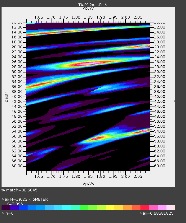
| Estimated Moho Depth: |
19.25 km |
| Estimated Crust Vp/Vs: |
2.10 |
| Assumed Crust Vp: |
6.276 km/s |
| Estimated Crust Vs: |
2.996 km/s |
| Estimated Crust Poisson's Ratio: |
0.35 |
|
| Radial Match: |
80.6845 % |
| Radial Bump: |
400 |
| Transverse Match: |
74.625 % |
| Transverse Bump: |
400 |
| SOD ConfigId: |
2564 |
| Insert Time: |
2010-03-06 03:17:00.387 +0000 |
| GWidth: |
2.5 |
| Max Bumps: |
400 |
| Tol: |
0.001 |
|

Signal To Noise
| Channel | StoN | STA | LTA |
| TA:P12A: :BHN:20070928T01:14:30.024011Z | 0.56513584 | 6.536826E-8 | 1.15668236E-7 |
| TA:P12A: :BHE:20070928T01:14:30.024011Z | 1.1988376 | 1.2567044E-7 | 1.0482692E-7 |
| TA:P12A: :BHZ:20070928T01:14:30.024011Z | 3.4627588 | 4.149443E-7 | 1.1983056E-7 |
| Arrivals |
| Ps | 3.4 SECOND |
| PpPs | 9.3 SECOND |
| PsPs/PpSs | 13 SECOND |


