You are here: Home > Network List > TA - USArray Transportable Network (new EarthScope stations) Stations List
> Station D25K Kavik River, AK, USA > Earthquake Result Viewer
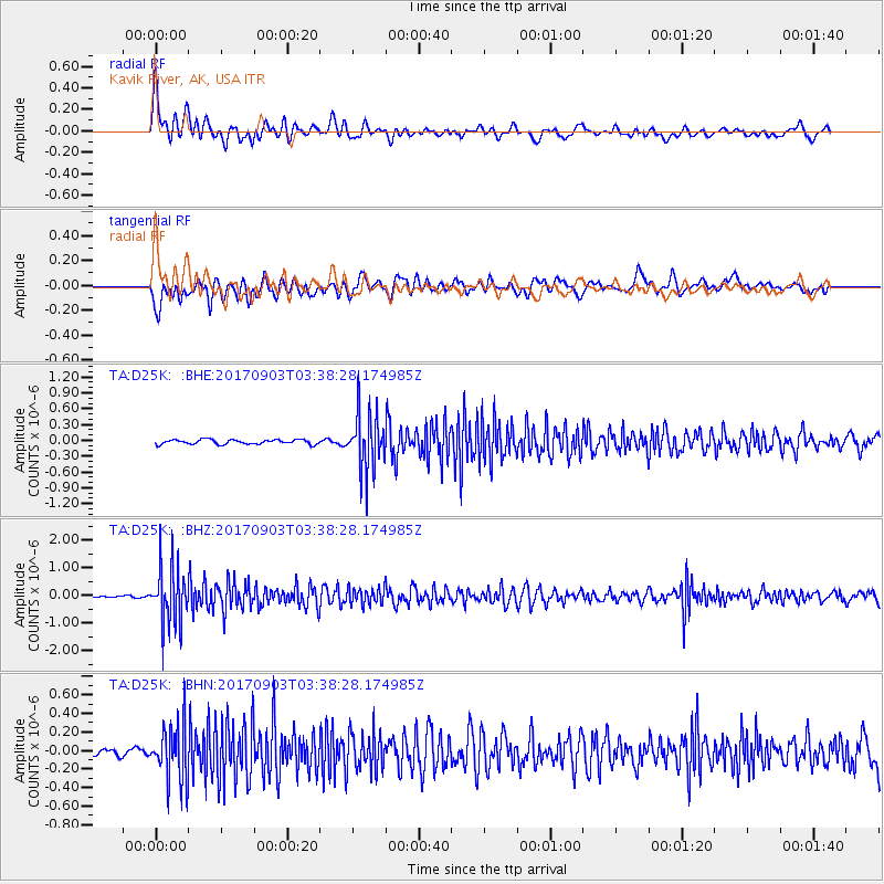
D25K Kavik River, AK, USA - Earthquake Result Viewer
*The percent match for this event was below the threshold and hence no stack was calculated.
| Earthquake location: |
North Korea |
| Earthquake latitude/longitude: |
41.3/129.0 |
| Earthquake time(UTC): |
2017/09/03 (246) 03:30:01 GMT |
| Earthquake Depth: |
0.0 km |
| Earthquake Magnitude: |
6.3 mb |
| Earthquake Catalog/Contributor: |
NEIC PDE/us |
|
| Network: |
TA USArray Transportable Network (new EarthScope stations) |
| Station: |
D25K Kavik River, AK, USA |
| Lat/Lon: |
69.32 N/146.38 W |
| Elevation: |
770 m |
|
| Distance: |
50.2 deg |
| Az: |
27.413 deg |
| Baz: |
282.586 deg |
| Ray Param: |
$rayparam |
*The percent match for this event was below the threshold and hence was not used in the summary stack. |
|
| Radial Match: |
78.62252 % |
| Radial Bump: |
400 |
| Transverse Match: |
74.15671 % |
| Transverse Bump: |
400 |
| SOD ConfigId: |
13570011 |
| Insert Time: |
2019-04-28 16:39:40.560 +0000 |
| GWidth: |
2.5 |
| Max Bumps: |
400 |
| Tol: |
0.001 |
|
Signal To Noise
| Channel | StoN | STA | LTA |
| TA:D25K: :BHZ:20170903T03:38:28.174985Z | 16.289015 | 1.0831644E-6 | 6.649662E-8 |
| TA:D25K: :BHN:20170903T03:38:28.174985Z | 4.5344553 | 3.0253196E-7 | 6.671847E-8 |
| TA:D25K: :BHE:20170903T03:38:28.174985Z | 12.18415 | 5.3267723E-7 | 4.371887E-8 |
| Arrivals |
| Ps | |
| PpPs | |
| PsPs/PpSs | |


