You are here: Home > Network List > TA - USArray Transportable Network (new EarthScope stations) Stations List
> Station G16K Koyuk River, AK, USA > Earthquake Result Viewer
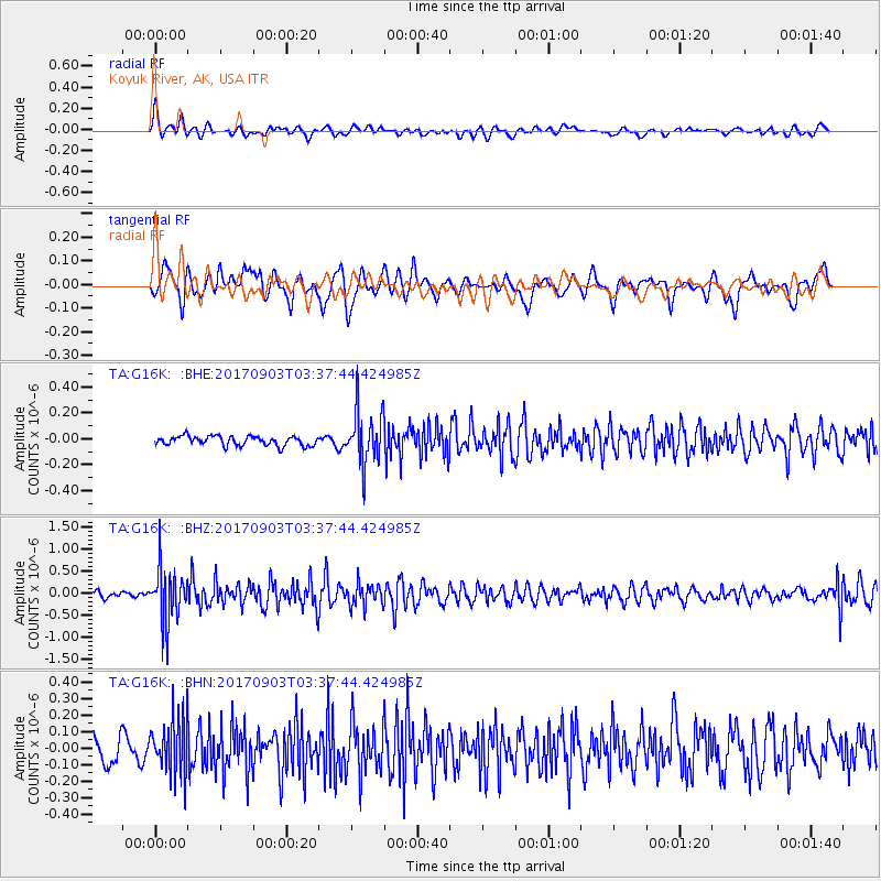
G16K Koyuk River, AK, USA - Earthquake Result Viewer
*The percent match for this event was below the threshold and hence no stack was calculated.
| Earthquake location: |
North Korea |
| Earthquake latitude/longitude: |
41.3/129.0 |
| Earthquake time(UTC): |
2017/09/03 (246) 03:30:01 GMT |
| Earthquake Depth: |
0.0 km |
| Earthquake Magnitude: |
6.3 mb |
| Earthquake Catalog/Contributor: |
NEIC PDE/us |
|
| Network: |
TA USArray Transportable Network (new EarthScope stations) |
| Station: |
G16K Koyuk River, AK, USA |
| Lat/Lon: |
65.39 N/162.35 W |
| Elevation: |
169 m |
|
| Distance: |
44.6 deg |
| Az: |
33.758 deg |
| Baz: |
272.135 deg |
| Ray Param: |
$rayparam |
*The percent match for this event was below the threshold and hence was not used in the summary stack. |
|
| Radial Match: |
75.32466 % |
| Radial Bump: |
400 |
| Transverse Match: |
61.40695 % |
| Transverse Bump: |
400 |
| SOD ConfigId: |
13570011 |
| Insert Time: |
2019-04-28 16:40:04.408 +0000 |
| GWidth: |
2.5 |
| Max Bumps: |
400 |
| Tol: |
0.001 |
|
Signal To Noise
| Channel | StoN | STA | LTA |
| TA:G16K: :BHZ:20170903T03:37:44.424985Z | 9.177731 | 6.176481E-7 | 6.7298565E-8 |
| TA:G16K: :BHN:20170903T03:37:44.424985Z | 2.3247519 | 1.62955E-7 | 7.009566E-8 |
| TA:G16K: :BHE:20170903T03:37:44.424985Z | 5.5628333 | 2.0284645E-7 | 3.6464595E-8 |
| Arrivals |
| Ps | |
| PpPs | |
| PsPs/PpSs | |


