You are here: Home > Network List > TA - USArray Transportable Network (new EarthScope stations) Stations List
> Station G31M Satah River, YT, CAN > Earthquake Result Viewer
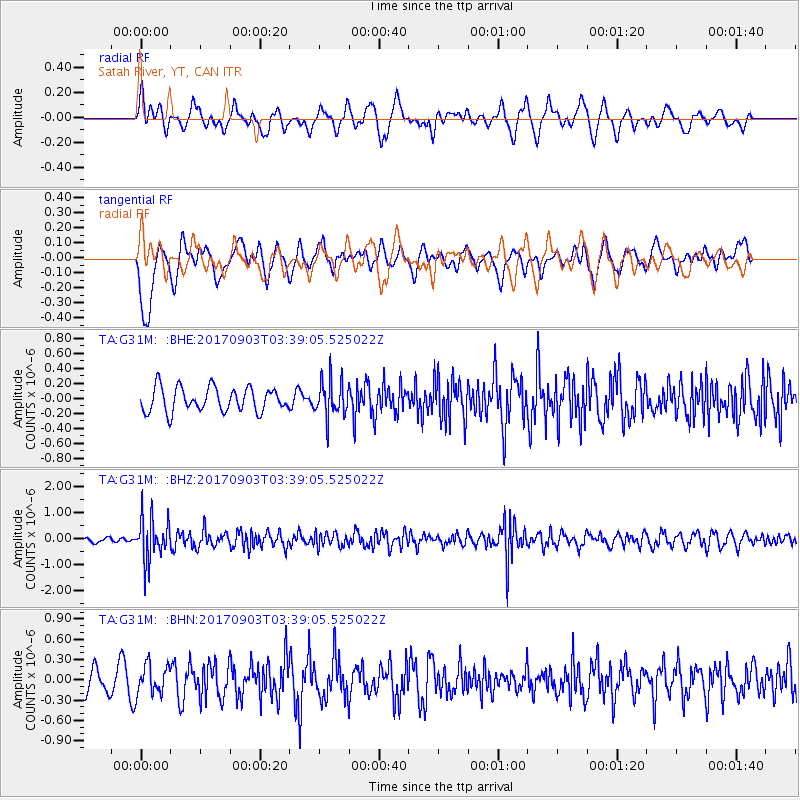
G31M Satah River, YT, CAN - Earthquake Result Viewer
*The percent match for this event was below the threshold and hence no stack was calculated.
| Earthquake location: |
North Korea |
| Earthquake latitude/longitude: |
41.3/129.0 |
| Earthquake time(UTC): |
2017/09/03 (246) 03:30:01 GMT |
| Earthquake Depth: |
0.0 km |
| Earthquake Magnitude: |
6.3 mb |
| Earthquake Catalog/Contributor: |
NEIC PDE/us |
|
| Network: |
TA USArray Transportable Network (new EarthScope stations) |
| Station: |
G31M Satah River, YT, CAN |
| Lat/Lon: |
66.92 N/134.27 W |
| Elevation: |
61 m |
|
| Distance: |
55.2 deg |
| Az: |
28.462 deg |
| Baz: |
294.453 deg |
| Ray Param: |
$rayparam |
*The percent match for this event was below the threshold and hence was not used in the summary stack. |
|
| Radial Match: |
70.72022 % |
| Radial Bump: |
400 |
| Transverse Match: |
45.89868 % |
| Transverse Bump: |
400 |
| SOD ConfigId: |
13570011 |
| Insert Time: |
2019-04-28 16:40:15.012 +0000 |
| GWidth: |
2.5 |
| Max Bumps: |
400 |
| Tol: |
0.001 |
|
Signal To Noise
| Channel | StoN | STA | LTA |
| TA:G31M: :BHZ:20170903T03:39:05.525022Z | 7.709539 | 8.1390266E-7 | 1.05570855E-7 |
| TA:G31M: :BHN:20170903T03:39:05.525022Z | 1.0733706 | 2.1639252E-7 | 2.0160094E-7 |
| TA:G31M: :BHE:20170903T03:39:05.525022Z | 1.5286962 | 2.4563542E-7 | 1.6068296E-7 |
| Arrivals |
| Ps | |
| PpPs | |
| PsPs/PpSs | |


