You are here: Home > Network List > TA - USArray Transportable Network (new EarthScope stations) Stations List
> Station P12A McGill, NV, USA > Earthquake Result Viewer
P12A McGill, NV, USA - Earthquake Result Viewer
| Earthquake location: |
Chile-Argentina Border Region |
| Earthquake latitude/longitude: |
-24.2/-67.0 |
| Earthquake time(UTC): |
2007/05/25 (145) 17:47:31 GMT |
| Earthquake Depth: |
180 km |
| Earthquake Magnitude: |
5.5 MB, 5.9 MW, 5.9 MW |
| Earthquake Catalog/Contributor: |
WHDF/NEIC |
|
| Network: |
TA USArray Transportable Network (new EarthScope stations) |
| Station: |
P12A McGill, NV, USA |
| Lat/Lon: |
39.47 N/114.91 W |
| Elevation: |
1878 m |
|
| Distance: |
77.5 deg |
| Az: |
323.988 deg |
| Baz: |
136.091 deg |
| Ray Param: |
0.04979057 |
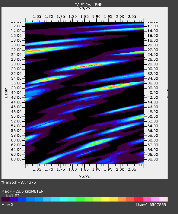
| Estimated Moho Depth: |
28.5 km |
| Estimated Crust Vp/Vs: |
1.87 |
| Assumed Crust Vp: |
6.276 km/s |
| Estimated Crust Vs: |
3.356 km/s |
| Estimated Crust Poisson's Ratio: |
0.30 |
|
| Radial Match: |
87.4375 % |
| Radial Bump: |
400 |
| Transverse Match: |
85.059685 % |
| Transverse Bump: |
400 |
| SOD ConfigId: |
2564 |
| Insert Time: |
2010-03-06 03:17:12.483 +0000 |
| GWidth: |
2.5 |
| Max Bumps: |
400 |
| Tol: |
0.001 |
|

Signal To Noise
| Channel | StoN | STA | LTA |
| TA:P12A: :BHN:20070525T17:58:36.049001Z | 3.80494 | 1.880302E-7 | 4.941739E-8 |
| TA:P12A: :BHE:20070525T17:58:36.049001Z | 9.281281 | 4.1698397E-7 | 4.492741E-8 |
| TA:P12A: :BHZ:20070525T17:58:36.049001Z | 18.234648 | 7.393597E-7 | 4.054697E-8 |
| Arrivals |
| Ps | 4.1 SECOND |
| PpPs | 13 SECOND |
| PsPs/PpSs | 17 SECOND |


