You are here: Home > Network List > TA - USArray Transportable Network (new EarthScope stations) Stations List
> Station H31M Peel River, Yukon, CAN > Earthquake Result Viewer
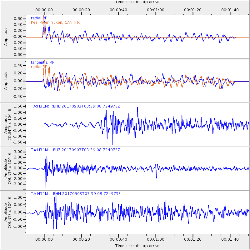
H31M Peel River, Yukon, CAN - Earthquake Result Viewer
*The percent match for this event was below the threshold and hence no stack was calculated.
| Earthquake location: |
North Korea |
| Earthquake latitude/longitude: |
41.3/129.0 |
| Earthquake time(UTC): |
2017/09/03 (246) 03:30:01 GMT |
| Earthquake Depth: |
0.0 km |
| Earthquake Magnitude: |
6.3 mb |
| Earthquake Catalog/Contributor: |
NEIC PDE/us |
|
| Network: |
TA USArray Transportable Network (new EarthScope stations) |
| Station: |
H31M Peel River, Yukon, CAN |
| Lat/Lon: |
65.81 N/134.34 W |
| Elevation: |
642 m |
|
| Distance: |
55.7 deg |
| Az: |
29.714 deg |
| Baz: |
295.097 deg |
| Ray Param: |
$rayparam |
*The percent match for this event was below the threshold and hence was not used in the summary stack. |
|
| Radial Match: |
68.82018 % |
| Radial Bump: |
400 |
| Transverse Match: |
59.962524 % |
| Transverse Bump: |
400 |
| SOD ConfigId: |
13570011 |
| Insert Time: |
2019-04-28 16:40:25.072 +0000 |
| GWidth: |
2.5 |
| Max Bumps: |
400 |
| Tol: |
0.001 |
|
Signal To Noise
| Channel | StoN | STA | LTA |
| TA:H31M: :BHZ:20170903T03:39:08.724973Z | 7.903271 | 1.1177361E-6 | 1.4142702E-7 |
| TA:H31M: :BHN:20170903T03:39:08.724973Z | 2.2774518 | 2.9146744E-7 | 1.2797963E-7 |
| TA:H31M: :BHE:20170903T03:39:08.724973Z | 4.7878714 | 5.2631395E-7 | 1.09926496E-7 |
| Arrivals |
| Ps | |
| PpPs | |
| PsPs/PpSs | |


