You are here: Home > Network List > TA - USArray Transportable Network (new EarthScope stations) Stations List
> Station I17K Unalakleet, AK, USA > Earthquake Result Viewer
I17K Unalakleet, AK, USA - Earthquake Result Viewer
*The percent match for this event was below the threshold and hence no stack was calculated.
| Earthquake location: |
North Korea |
| Earthquake latitude/longitude: |
41.3/129.0 |
| Earthquake time(UTC): |
2017/09/03 (246) 03:30:01 GMT |
| Earthquake Depth: |
0.0 km |
| Earthquake Magnitude: |
6.3 mb |
| Earthquake Catalog/Contributor: |
NEIC PDE/us |
|
| Network: |
TA USArray Transportable Network (new EarthScope stations) |
| Station: |
I17K Unalakleet, AK, USA |
| Lat/Lon: |
63.89 N/160.70 W |
| Elevation: |
105 m |
|
| Distance: |
45.4 deg |
| Az: |
35.831 deg |
| Baz: |
275.1 deg |
| Ray Param: |
$rayparam |
*The percent match for this event was below the threshold and hence was not used in the summary stack. |
|
| Radial Match: |
72.456024 % |
| Radial Bump: |
400 |
| Transverse Match: |
58.20462 % |
| Transverse Bump: |
400 |
| SOD ConfigId: |
13570011 |
| Insert Time: |
2019-04-28 16:40:26.613 +0000 |
| GWidth: |
2.5 |
| Max Bumps: |
400 |
| Tol: |
0.001 |
|
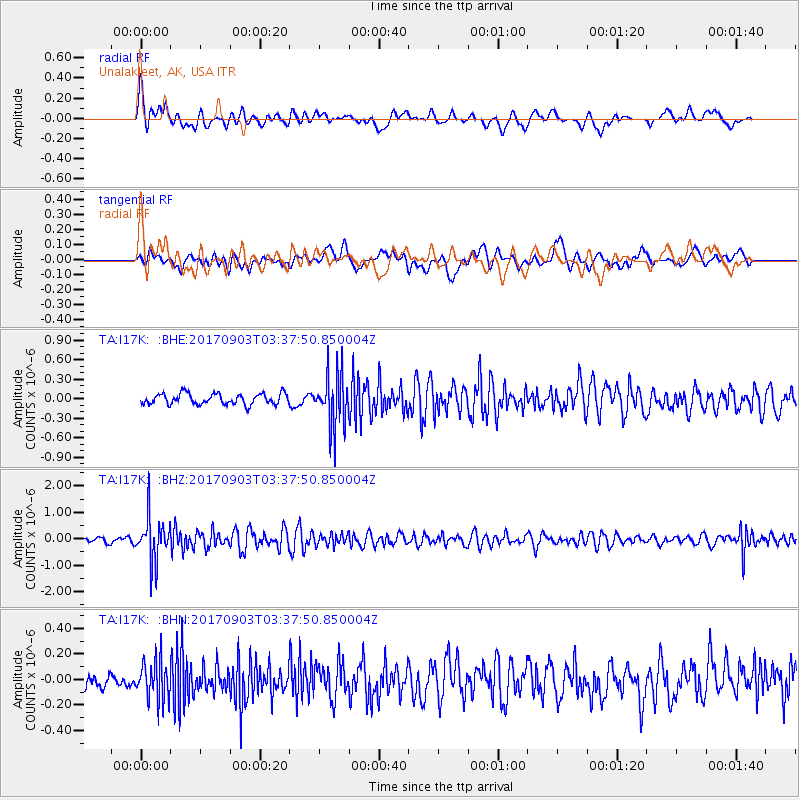
Signal To Noise
| Channel | StoN | STA | LTA |
| TA:I17K: :BHZ:20170903T03:37:50.850004Z | 8.621054 | 8.2923816E-7 | 9.618756E-8 |
| TA:I17K: :BHN:20170903T03:37:50.850004Z | 2.34391 | 1.553153E-7 | 6.626334E-8 |
| TA:I17K: :BHE:20170903T03:37:50.850004Z | 4.956088 | 4.1265798E-7 | 8.326285E-8 |
| Arrivals |
| Ps | |
| PpPs | |
| PsPs/PpSs | |


