You are here: Home > Network List > TA - USArray Transportable Network (new EarthScope stations) Stations List
> Station I30M Mount Dempster, Yukon, CAN > Earthquake Result Viewer
I30M Mount Dempster, Yukon, CAN - Earthquake Result Viewer
| Earthquake location: |
North Korea |
| Earthquake latitude/longitude: |
41.3/129.0 |
| Earthquake time(UTC): |
2017/09/03 (246) 03:30:01 GMT |
| Earthquake Depth: |
0.0 km |
| Earthquake Magnitude: |
6.3 mb |
| Earthquake Catalog/Contributor: |
NEIC PDE/us |
|
| Network: |
TA USArray Transportable Network (new EarthScope stations) |
| Station: |
I30M Mount Dempster, Yukon, CAN |
| Lat/Lon: |
65.22 N/136.38 W |
| Elevation: |
1399 m |
|
| Distance: |
55.2 deg |
| Az: |
30.788 deg |
| Baz: |
293.857 deg |
| Ray Param: |
0.06500664 |
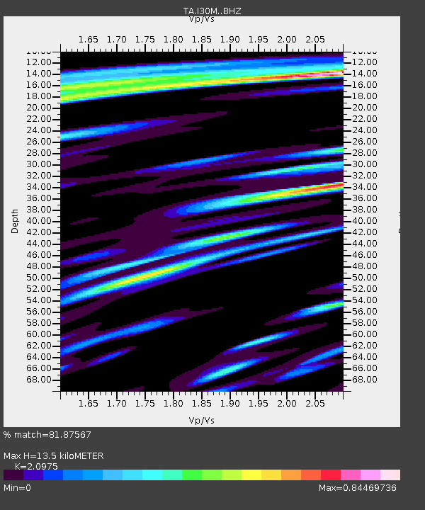
| Estimated Moho Depth: |
13.5 km |
| Estimated Crust Vp/Vs: |
2.10 |
| Assumed Crust Vp: |
6.566 km/s |
| Estimated Crust Vs: |
3.13 km/s |
| Estimated Crust Poisson's Ratio: |
0.35 |
|
| Radial Match: |
81.87567 % |
| Radial Bump: |
400 |
| Transverse Match: |
78.575455 % |
| Transverse Bump: |
400 |
| SOD ConfigId: |
13570011 |
| Insert Time: |
2019-04-28 16:40:33.856 +0000 |
| GWidth: |
2.5 |
| Max Bumps: |
400 |
| Tol: |
0.001 |
|
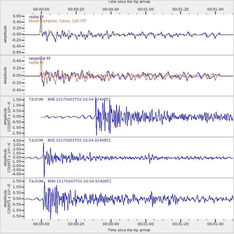
Signal To Noise
| Channel | StoN | STA | LTA |
| TA:I30M: :BHZ:20170903T03:39:04.924985Z | 15.94653 | 1.3828776E-6 | 8.671966E-8 |
| TA:I30M: :BHN:20170903T03:39:04.924985Z | 8.655758 | 5.8700135E-7 | 6.781629E-8 |
| TA:I30M: :BHE:20170903T03:39:04.924985Z | 11.396168 | 6.380632E-7 | 5.5989275E-8 |
| Arrivals |
| Ps | 2.4 SECOND |
| PpPs | 6.1 SECOND |
| PsPs/PpSs | 8.4 SECOND |


