You are here: Home > Network List > TA - USArray Transportable Network (new EarthScope stations) Stations List
> Station M31M Drury Creek, Yukon, CA > Earthquake Result Viewer
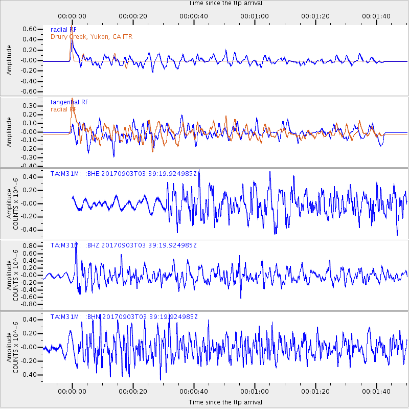
M31M Drury Creek, Yukon, CA - Earthquake Result Viewer
*The percent match for this event was below the threshold and hence no stack was calculated.
| Earthquake location: |
North Korea |
| Earthquake latitude/longitude: |
41.3/129.0 |
| Earthquake time(UTC): |
2017/09/03 (246) 03:30:01 GMT |
| Earthquake Depth: |
0.0 km |
| Earthquake Magnitude: |
6.3 mb |
| Earthquake Catalog/Contributor: |
NEIC PDE/us |
|
| Network: |
TA USArray Transportable Network (new EarthScope stations) |
| Station: |
M31M Drury Creek, Yukon, CA |
| Lat/Lon: |
62.20 N/134.39 W |
| Elevation: |
639 m |
|
| Distance: |
57.3 deg |
| Az: |
33.621 deg |
| Baz: |
297.213 deg |
| Ray Param: |
$rayparam |
*The percent match for this event was below the threshold and hence was not used in the summary stack. |
|
| Radial Match: |
61.610687 % |
| Radial Bump: |
400 |
| Transverse Match: |
55.214615 % |
| Transverse Bump: |
400 |
| SOD ConfigId: |
13570011 |
| Insert Time: |
2019-04-28 16:41:09.771 +0000 |
| GWidth: |
2.5 |
| Max Bumps: |
400 |
| Tol: |
0.001 |
|
Signal To Noise
| Channel | StoN | STA | LTA |
| TA:M31M: :BHZ:20170903T03:39:19.924985Z | 5.220495 | 3.330659E-7 | 6.3799675E-8 |
| TA:M31M: :BHN:20170903T03:39:19.924985Z | 2.283273 | 1.8019574E-7 | 7.891993E-8 |
| TA:M31M: :BHE:20170903T03:39:19.924985Z | 3.1462007 | 1.7762335E-7 | 5.6456457E-8 |
| Arrivals |
| Ps | |
| PpPs | |
| PsPs/PpSs | |


