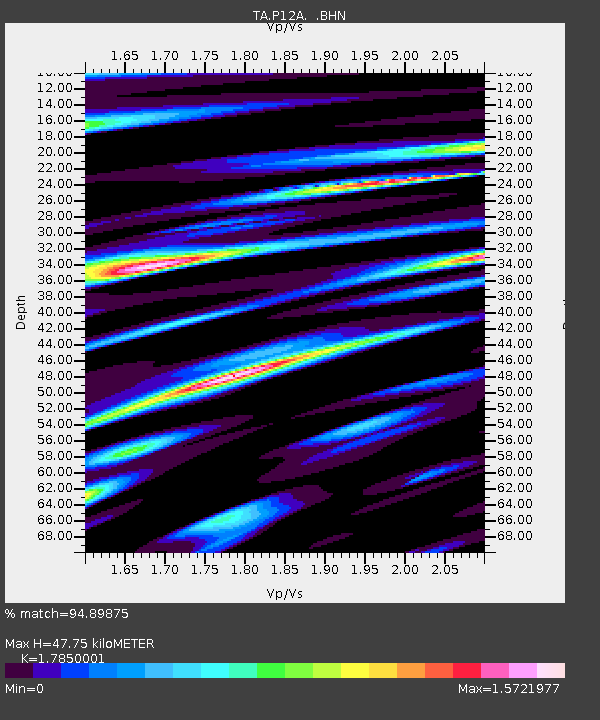
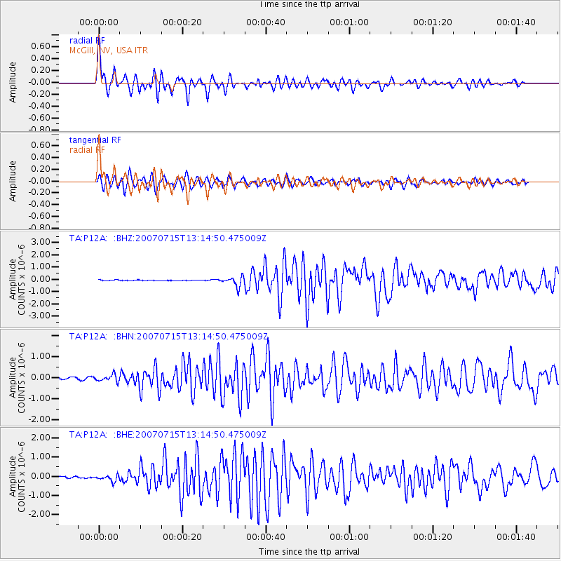
P12A McGill, NV, USA - Earthquake Result Viewer

Earthquake location: Fox Islands, Aleutian Islands
Earthquake latitude/longitude: 52.5/-168.0
Earthquake time(UTC): 2007/07/15 (196) 13:08:00 GMT
Earthquake Depth: 10 km
Earthquake Magnitude: 5.8 MB, 5.9 MS, 6.1 MW, 6.0 MW
Earthquake Catalog/Contributor: WHDF/NEIC
Network: TA USArray Transportable Network (new EarthScope stations)
Station: P12A McGill, NV, USA
Lat/Lon: 39.47 N/114.91 W
Elevation: 1878 m
Distance: 38.3 deg
Az: 88.157 deg
Baz: 307.834 deg
Ray Param: 0.07564883
Estimated Moho Depth: 47.75 km
Estimated Crust Vp/Vs: 1.79
Assumed Crust Vp: 6.276 km/s
Estimated Crust Vs: 3.516 km/s
Estimated Crust Poisson's Ratio: 0.27
Radial Match: 94.89875 %
Radial Bump: 400
Transverse Match: 89.45119 %
Transverse Bump: 400
SOD ConfigId: 2564
Insert Time: 2010-03-06 03:17:25.788 +0000
GWidth: 2.5
Max Bumps: 400
Tol: 0.001

Signal To Noise

ChannelStoNSTALTA
TA:P12A: :BHN:20070715T13:14:50.475009Z2.80813241.6367552E-75.8286258E-8
TA:P12A: :BHE:20070715T13:14:50.475009Z4.87728741.6101612E-73.3013457E-8
TA:P12A: :BHZ:20070715T13:14:50.475009Z13.4603664.014505E-72.9824633E-8
Arrivals
Ps6.4 SECOND
PpPs20 SECOND
PsPs/PpSs26 SECOND