You are here: Home > Network List > TA - USArray Transportable Network (new EarthScope stations) Stations List
> Station R17K Ugashik Creek, AK, USA > Earthquake Result Viewer
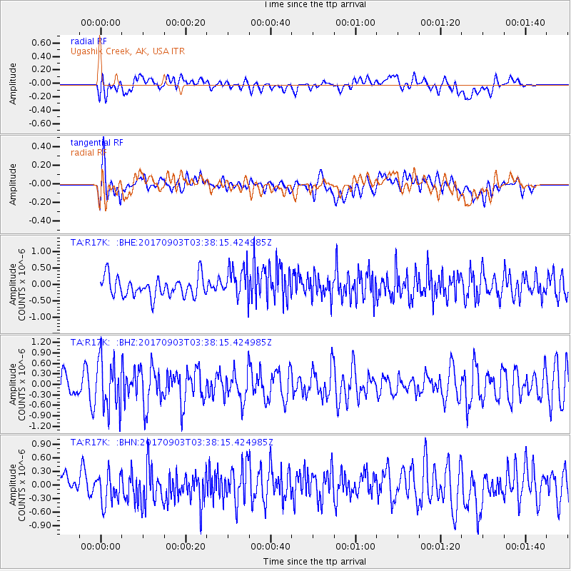
R17K Ugashik Creek, AK, USA - Earthquake Result Viewer
*The percent match for this event was below the threshold and hence no stack was calculated.
| Earthquake location: |
North Korea |
| Earthquake latitude/longitude: |
41.3/129.0 |
| Earthquake time(UTC): |
2017/09/03 (246) 03:30:01 GMT |
| Earthquake Depth: |
0.0 km |
| Earthquake Magnitude: |
6.3 mb |
| Earthquake Catalog/Contributor: |
NEIC PDE/us |
|
| Network: |
TA USArray Transportable Network (new EarthScope stations) |
| Station: |
R17K Ugashik Creek, AK, USA |
| Lat/Lon: |
57.64 N/156.39 W |
| Elevation: |
273 m |
|
| Distance: |
48.5 deg |
| Az: |
43.797 deg |
| Baz: |
284.305 deg |
| Ray Param: |
$rayparam |
*The percent match for this event was below the threshold and hence was not used in the summary stack. |
|
| Radial Match: |
49.772255 % |
| Radial Bump: |
400 |
| Transverse Match: |
57.156002 % |
| Transverse Bump: |
400 |
| SOD ConfigId: |
13570011 |
| Insert Time: |
2019-04-28 16:41:43.857 +0000 |
| GWidth: |
2.5 |
| Max Bumps: |
400 |
| Tol: |
0.001 |
|
Signal To Noise
| Channel | StoN | STA | LTA |
| TA:R17K: :BHZ:20170903T03:38:15.424985Z | 2.8080976 | 7.1381476E-7 | 2.5419868E-7 |
| TA:R17K: :BHN:20170903T03:38:15.424985Z | 0.78947145 | 3.3162917E-7 | 4.200648E-7 |
| TA:R17K: :BHE:20170903T03:38:15.424985Z | 1.6901107 | 5.018082E-7 | 2.9690847E-7 |
| Arrivals |
| Ps | |
| PpPs | |
| PsPs/PpSs | |


