You are here: Home > Network List > TA - USArray Transportable Network (new EarthScope stations) Stations List
> Station P12A McGill, NV, USA > Earthquake Result Viewer
P12A McGill, NV, USA - Earthquake Result Viewer

| Earthquake location: |
Near Coast Of Peru |
| Earthquake latitude/longitude: |
-15.7/-74.9 |
| Earthquake time(UTC): |
2007/06/28 (179) 08:44:48 GMT |
| Earthquake Depth: |
27 km |
| Earthquake Magnitude: |
5.5 MB, 5.3 MS, 5.8 MW, 5.8 MW |
| Earthquake Catalog/Contributor: |
WHDF/NEIC |
|
| Network: |
TA USArray Transportable Network (new EarthScope stations) |
| Station: |
P12A McGill, NV, USA |
| Lat/Lon: |
39.47 N/114.91 W |
| Elevation: |
1878 m |
|
| Distance: |
66.4 deg |
| Az: |
327.094 deg |
| Baz: |
137.463 deg |
| Ray Param: |
0.057623714 |
| Estimated Moho Depth: |
36.0 km |
| Estimated Crust Vp/Vs: |
1.67 |
| Assumed Crust Vp: |
6.276 km/s |
| Estimated Crust Vs: |
3.764 km/s |
| Estimated Crust Poisson's Ratio: |
0.22 |
|
| Radial Match: |
88.014725 % |
| Radial Bump: |
400 |
| Transverse Match: |
83.78131 % |
| Transverse Bump: |
400 |
| SOD ConfigId: |
2564 |
| Insert Time: |
2010-03-06 03:17:34.869 +0000 |
| GWidth: |
2.5 |
| Max Bumps: |
400 |
| Tol: |
0.001 |
|
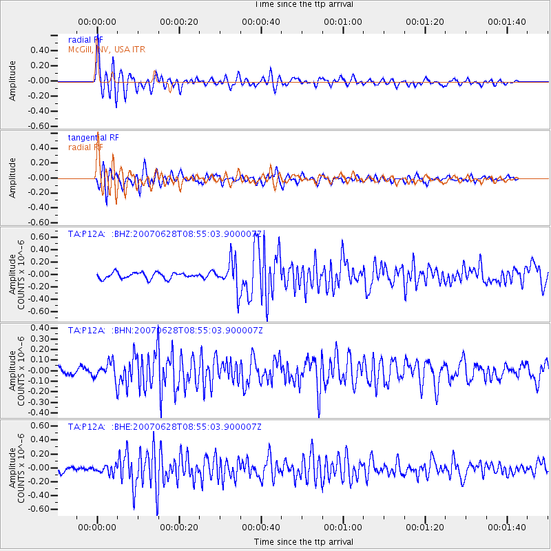
Signal To Noise
| Channel | StoN | STA | LTA |
| TA:P12A: :BHN:20070628T08:55:03.900007Z | 2.0768342 | 8.311398E-8 | 4.0019557E-8 |
| TA:P12A: :BHE:20070628T08:55:03.900007Z | 1.6779199 | 5.803304E-8 | 3.4586304E-8 |
| TA:P12A: :BHZ:20070628T08:55:03.900007Z | 4.9695835 | 2.4364024E-7 | 4.9026287E-8 |
| Arrivals |
| Ps | 4.0 SECOND |
| PpPs | 15 SECOND |
| PsPs/PpSs | 19 SECOND |


