You are here: Home > Network List > UW - Pacific Northwest Regional Seismic Network Stations List
> Station MRBL Marblemount, WA, USA > Earthquake Result Viewer
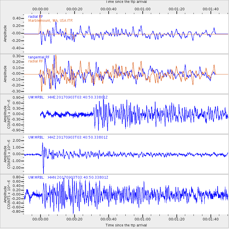
MRBL Marblemount, WA, USA - Earthquake Result Viewer
*The percent match for this event was below the threshold and hence no stack was calculated.
| Earthquake location: |
North Korea |
| Earthquake latitude/longitude: |
41.3/129.0 |
| Earthquake time(UTC): |
2017/09/03 (246) 03:30:01 GMT |
| Earthquake Depth: |
0.0 km |
| Earthquake Magnitude: |
6.3 mb |
| Earthquake Catalog/Contributor: |
NEIC PDE/us |
|
| Network: |
UW Pacific Northwest Regional Seismic Network |
| Station: |
MRBL Marblemount, WA, USA |
| Lat/Lon: |
48.52 N/121.48 W |
| Elevation: |
75 m |
|
| Distance: |
71.1 deg |
| Az: |
41.506 deg |
| Baz: |
311.366 deg |
| Ray Param: |
$rayparam |
*The percent match for this event was below the threshold and hence was not used in the summary stack. |
|
| Radial Match: |
65.0777 % |
| Radial Bump: |
400 |
| Transverse Match: |
73.789795 % |
| Transverse Bump: |
400 |
| SOD ConfigId: |
13570011 |
| Insert Time: |
2019-04-28 16:42:59.061 +0000 |
| GWidth: |
2.5 |
| Max Bumps: |
400 |
| Tol: |
0.001 |
|
Signal To Noise
| Channel | StoN | STA | LTA |
| UW:MRBL: :HHZ:20170903T03:40:50.33801Z | 11.743658 | 8.1081873E-7 | 6.904311E-8 |
| UW:MRBL: :HHN:20170903T03:40:50.33801Z | 2.4819493 | 2.5459778E-7 | 1.0257976E-7 |
| UW:MRBL: :HHE:20170903T03:40:50.33801Z | 4.0852904 | 3.3856216E-7 | 8.2873456E-8 |
| Arrivals |
| Ps | |
| PpPs | |
| PsPs/PpSs | |


