You are here: Home > Network List > TA - USArray Transportable Network (new EarthScope stations) Stations List
> Station P12A McGill, NV, USA > Earthquake Result Viewer
P12A McGill, NV, USA - Earthquake Result Viewer
| Earthquake location: |
Kuril Islands |
| Earthquake latitude/longitude: |
46.3/153.3 |
| Earthquake time(UTC): |
2006/10/13 (286) 13:47:39 GMT |
| Earthquake Depth: |
8.0 km |
| Earthquake Magnitude: |
5.5 MB, 5.8 MS, 6.3 MW, 5.8 MW |
| Earthquake Catalog/Contributor: |
WHDF/NEIC |
|
| Network: |
TA USArray Transportable Network (new EarthScope stations) |
| Station: |
P12A McGill, NV, USA |
| Lat/Lon: |
39.47 N/114.91 W |
| Elevation: |
1878 m |
|
| Distance: |
64.0 deg |
| Az: |
59.429 deg |
| Baz: |
309.476 deg |
| Ray Param: |
0.059236135 |
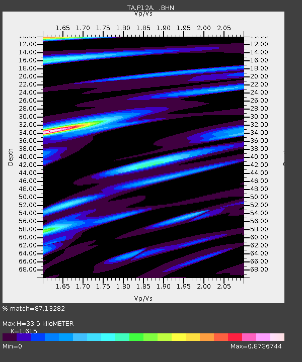
| Estimated Moho Depth: |
33.5 km |
| Estimated Crust Vp/Vs: |
1.62 |
| Assumed Crust Vp: |
6.276 km/s |
| Estimated Crust Vs: |
3.886 km/s |
| Estimated Crust Poisson's Ratio: |
0.19 |
|
| Radial Match: |
87.13282 % |
| Radial Bump: |
400 |
| Transverse Match: |
70.17045 % |
| Transverse Bump: |
400 |
| SOD ConfigId: |
2665 |
| Insert Time: |
2010-03-06 03:18:02.334 +0000 |
| GWidth: |
2.5 |
| Max Bumps: |
400 |
| Tol: |
0.001 |
|

Signal To Noise
| Channel | StoN | STA | LTA |
| TA:P12A: :BHN:20061013T13:57:42.350022Z | 0.88017 | 9.055194E-8 | 1.02880065E-7 |
| TA:P12A: :BHE:20061013T13:57:42.350022Z | 1.9112948 | 1.4646534E-7 | 7.663148E-8 |
| TA:P12A: :BHZ:20061013T13:57:42.350022Z | 6.8484917 | 5.2776124E-7 | 7.70624E-8 |
| Arrivals |
| Ps | 3.4 SECOND |
| PpPs | 13 SECOND |
| PsPs/PpSs | 17 SECOND |


