You are here: Home > Network List > TA - USArray Transportable Network (new EarthScope stations) Stations List
> Station P12A McGill, NV, USA > Earthquake Result Viewer
P12A McGill, NV, USA - Earthquake Result Viewer
| Earthquake location: |
Near Coast Of Central Chile |
| Earthquake latitude/longitude: |
-31.3/-71.3 |
| Earthquake time(UTC): |
2006/10/12 (285) 18:05:58 GMT |
| Earthquake Depth: |
46 km |
| Earthquake Magnitude: |
5.8 MB, 6.1 MS, 6.4 MW, 6.3 MW |
| Earthquake Catalog/Contributor: |
WHDF/NEIC |
|
| Network: |
TA USArray Transportable Network (new EarthScope stations) |
| Station: |
P12A McGill, NV, USA |
| Lat/Lon: |
39.47 N/114.91 W |
| Elevation: |
1878 m |
|
| Distance: |
81.2 deg |
| Az: |
327.324 deg |
| Baz: |
143.34 deg |
| Ray Param: |
0.047660373 |
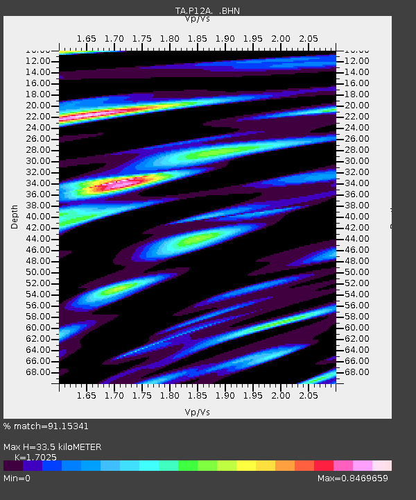
| Estimated Moho Depth: |
33.5 km |
| Estimated Crust Vp/Vs: |
1.70 |
| Assumed Crust Vp: |
6.276 km/s |
| Estimated Crust Vs: |
3.686 km/s |
| Estimated Crust Poisson's Ratio: |
0.24 |
|
| Radial Match: |
91.15341 % |
| Radial Bump: |
400 |
| Transverse Match: |
78.975525 % |
| Transverse Bump: |
400 |
| SOD ConfigId: |
2665 |
| Insert Time: |
2010-03-06 03:18:04.249 +0000 |
| GWidth: |
2.5 |
| Max Bumps: |
400 |
| Tol: |
0.001 |
|
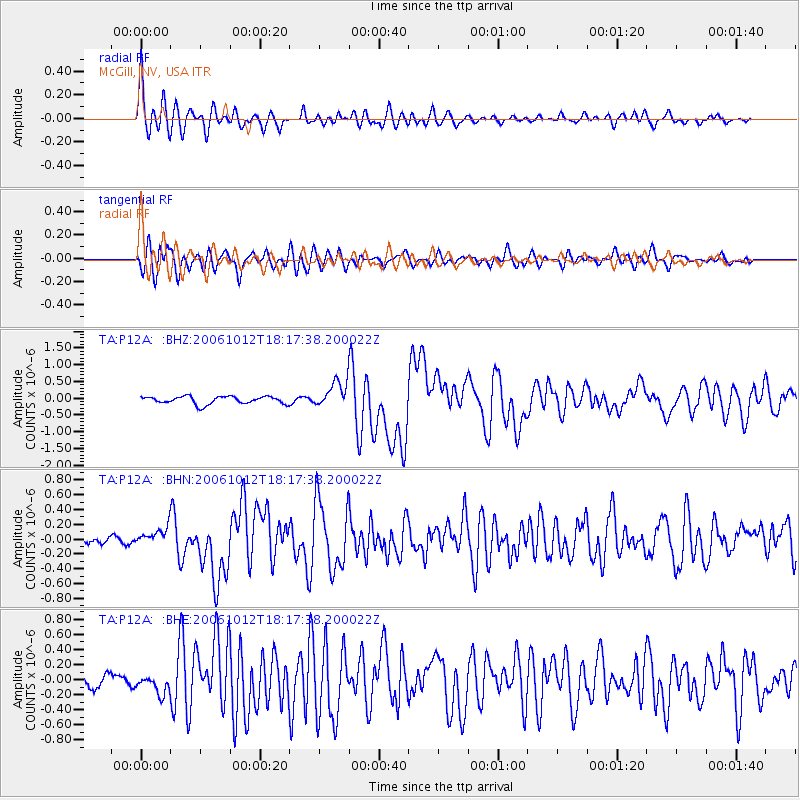
Signal To Noise
| Channel | StoN | STA | LTA |
| TA:P12A: :BHN:20061012T18:17:38.200022Z | 1.3183488 | 1.2323027E-7 | 9.34732E-8 |
| TA:P12A: :BHE:20061012T18:17:38.200022Z | 1.1479856 | 1.251718E-7 | 1.0903603E-7 |
| TA:P12A: :BHZ:20061012T18:17:38.200022Z | 3.471994 | 3.9311072E-7 | 1.1322334E-7 |
| Arrivals |
| Ps | 3.9 SECOND |
| PpPs | 14 SECOND |
| PsPs/PpSs | 18 SECOND |


