You are here: Home > Network List > II - Global Seismograph Network (GSN - IRIS/IDA) Stations List
> Station WRAB Tennant Creek, NT, Australia > Earthquake Result Viewer
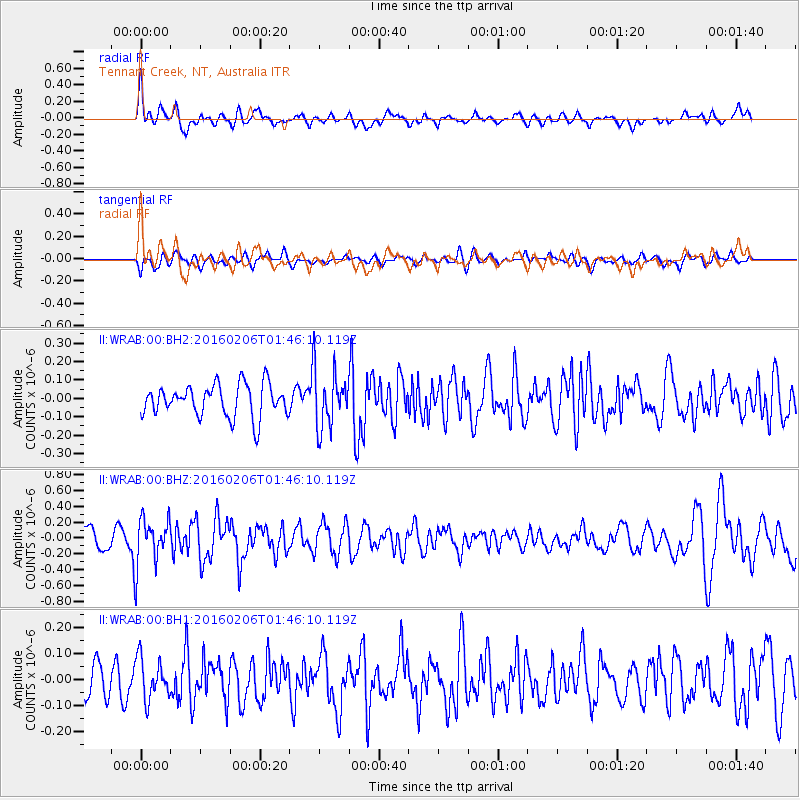
WRAB Tennant Creek, NT, Australia - Earthquake Result Viewer
*The percent match for this event was below the threshold and hence no stack was calculated.
| Earthquake location: |
Fiji Islands Region |
| Earthquake latitude/longitude: |
-17.0/174.9 |
| Earthquake time(UTC): |
2016/02/06 (037) 01:39:18 GMT |
| Earthquake Depth: |
10 km |
| Earthquake Magnitude: |
5.5 MB |
| Earthquake Catalog/Contributor: |
NEIC PDE/NEIC COMCAT |
|
| Network: |
II Global Seismograph Network (GSN - IRIS/IDA) |
| Station: |
WRAB Tennant Creek, NT, Australia |
| Lat/Lon: |
19.93 S/134.36 E |
| Elevation: |
366 m |
|
| Distance: |
38.5 deg |
| Az: |
259.209 deg |
| Baz: |
92.495 deg |
| Ray Param: |
$rayparam |
*The percent match for this event was below the threshold and hence was not used in the summary stack. |
|
| Radial Match: |
67.93565 % |
| Radial Bump: |
400 |
| Transverse Match: |
45.61812 % |
| Transverse Bump: |
400 |
| SOD ConfigId: |
1427151 |
| Insert Time: |
2016-02-20 01:46:30.157 +0000 |
| GWidth: |
2.5 |
| Max Bumps: |
400 |
| Tol: |
0.001 |
|
Signal To Noise
| Channel | StoN | STA | LTA |
| II:WRAB:00:BHZ:20160206T01:46:10.119Z | 2.4676144 | 2.9636175E-7 | 1.2010051E-7 |
| II:WRAB:00:BH1:20160206T01:46:10.119Z | 0.89757407 | 7.798021E-8 | 8.6878856E-8 |
| II:WRAB:00:BH2:20160206T01:46:10.119Z | 1.8021747 | 1.5652243E-7 | 8.685197E-8 |
| Arrivals |
| Ps | |
| PpPs | |
| PsPs/PpSs | |


