You are here: Home > Network List > TA - USArray Transportable Network (new EarthScope stations) Stations List
> Station P12A McGill, NV, USA > Earthquake Result Viewer
P12A McGill, NV, USA - Earthquake Result Viewer
| Earthquake location: |
Santiago Del Estero Prov., Arg. |
| Earthquake latitude/longitude: |
-26.9/-63.1 |
| Earthquake time(UTC): |
2006/09/22 (265) 02:32:25 GMT |
| Earthquake Depth: |
598 km |
| Earthquake Magnitude: |
6.1 MB, 6.0 MW, 6.0 MW |
| Earthquake Catalog/Contributor: |
WHDF/NEIC |
|
| Network: |
TA USArray Transportable Network (new EarthScope stations) |
| Station: |
P12A McGill, NV, USA |
| Lat/Lon: |
39.47 N/114.91 W |
| Elevation: |
1878 m |
|
| Distance: |
81.8 deg |
| Az: |
322.102 deg |
| Baz: |
134.854 deg |
| Ray Param: |
0.04554949 |
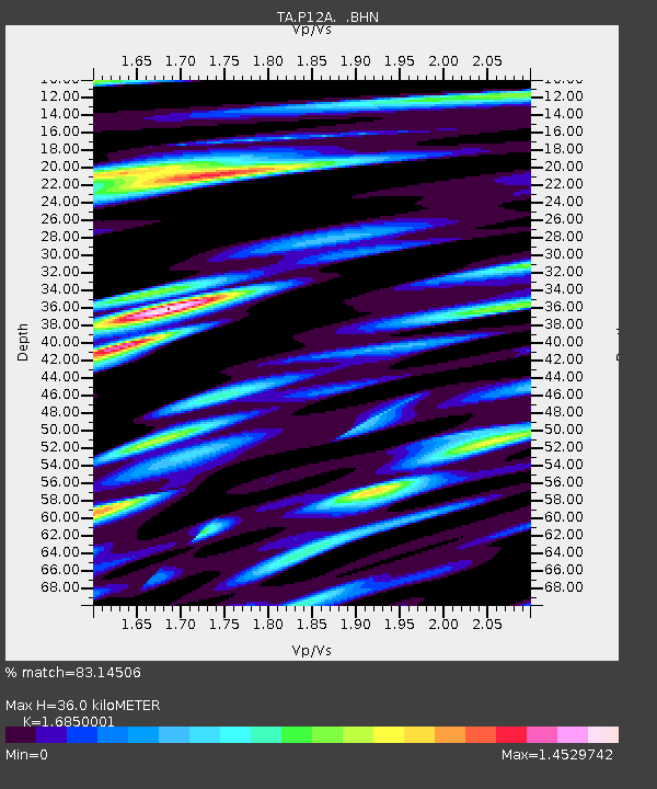
| Estimated Moho Depth: |
36.0 km |
| Estimated Crust Vp/Vs: |
1.69 |
| Assumed Crust Vp: |
6.276 km/s |
| Estimated Crust Vs: |
3.725 km/s |
| Estimated Crust Poisson's Ratio: |
0.23 |
|
| Radial Match: |
83.14506 % |
| Radial Bump: |
400 |
| Transverse Match: |
78.7626 % |
| Transverse Bump: |
400 |
| SOD ConfigId: |
2665 |
| Insert Time: |
2010-03-06 03:18:10.110 +0000 |
| GWidth: |
2.5 |
| Max Bumps: |
400 |
| Tol: |
0.001 |
|
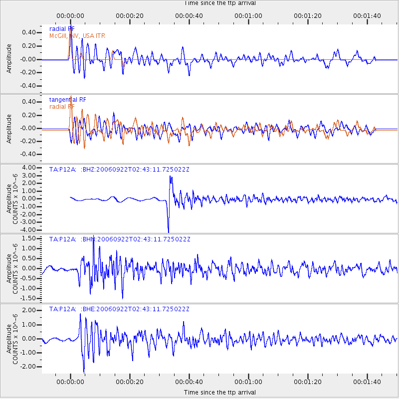
Signal To Noise
| Channel | StoN | STA | LTA |
| TA:P12A: :BHN:20060922T02:43:11.725022Z | 2.0578778 | 3.2452266E-7 | 1.5769773E-7 |
| TA:P12A: :BHE:20060922T02:43:11.725022Z | 4.482785 | 8.137539E-7 | 1.8152863E-7 |
| TA:P12A: :BHZ:20060922T02:43:11.725022Z | 9.382151 | 1.5439634E-6 | 1.6456391E-7 |
| Arrivals |
| Ps | 4.0 SECOND |
| PpPs | 15 SECOND |
| PsPs/PpSs | 19 SECOND |


