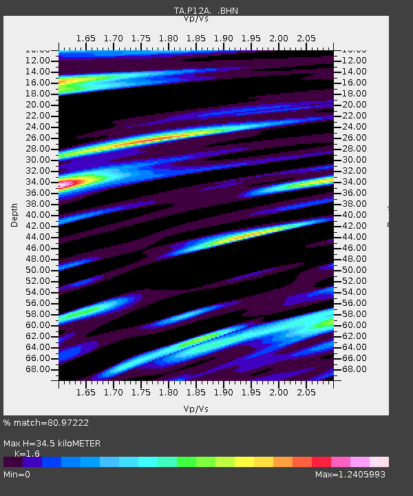
P12A McGill, NV, USA - Earthquake Result Viewer
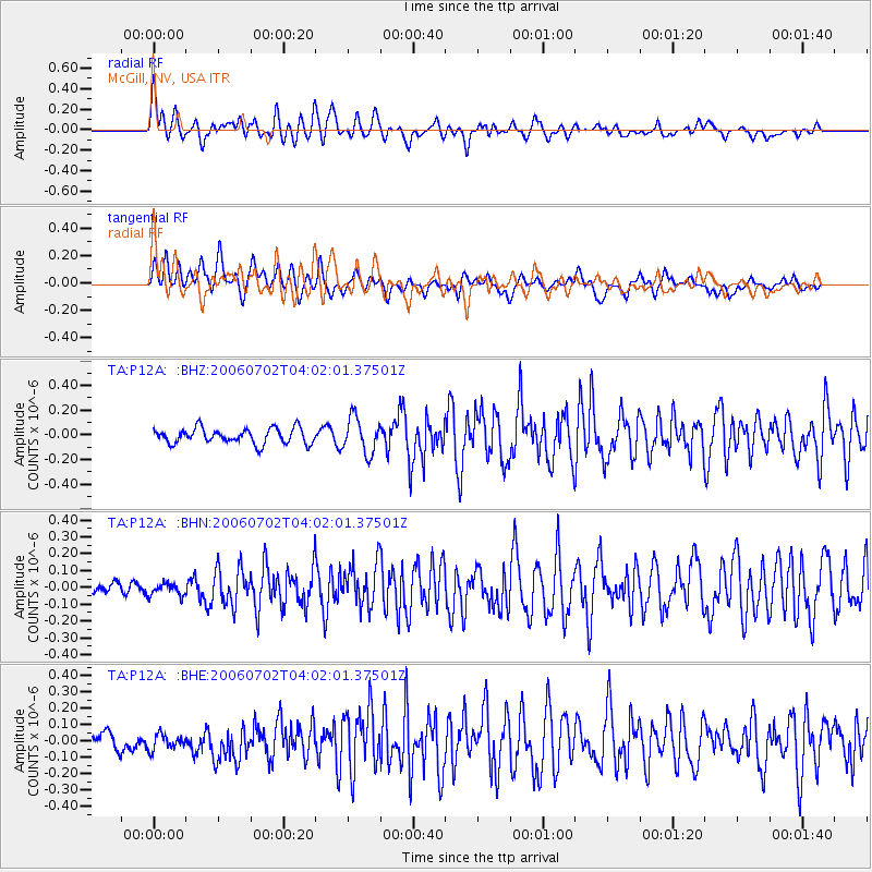
Earthquake location: Rat Islands, Aleutian Islands
Earthquake latitude/longitude: 51.7/176.9
Earthquake time(UTC): 2006/07/02 (183) 03:53:56 GMT
Earthquake Depth: 8.6 km
Earthquake Magnitude: 5.5 MB, 5.3 MS, 5.8 MW, 5.7 MW
Earthquake Catalog/Contributor: WHDF/NEIC
Network: TA USArray Transportable Network (new EarthScope stations)
Station: P12A McGill, NV, USA
Lat/Lon: 39.47 N/114.91 W
Elevation: 1878 m
Distance: 47.6 deg
Az: 76.799 deg
Baz: 308.503 deg
Ray Param: 0.0699139
Estimated Moho Depth: 34.5 km
Estimated Crust Vp/Vs: 1.60
Assumed Crust Vp: 6.276 km/s
Estimated Crust Vs: 3.922 km/s
Estimated Crust Poisson's Ratio: 0.18
Radial Match: 80.97222 %
Radial Bump: 400
Transverse Match: 76.151375 %
Transverse Bump: 400
SOD ConfigId: 2665
Insert Time: 2010-03-06 03:18:26.288 +0000
GWidth: 2.5
Max Bumps: 400
Tol: 0.001

Signal To Noise

ChannelStoNSTALTA
TA:P12A: :BHN:20060702T04:02:01.37501Z0.690424563.9125112E-85.6668192E-8
TA:P12A: :BHE:20060702T04:02:01.37501Z0.99979754.9340127E-84.9350117E-8
TA:P12A: :BHZ:20060702T04:02:01.37501Z2.32473131.4327765E-76.1631916E-8
Arrivals
Ps3.5 SECOND
PpPs13 SECOND
PsPs/PpSs17 SECOND