You are here: Home > Network List > YT07 - POLENET Stations List
> Station MPAT MPAT > Earthquake Result Viewer
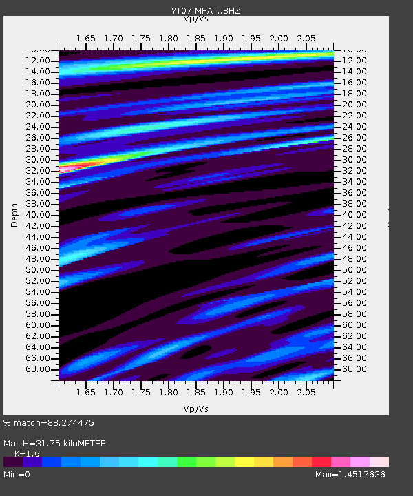
MPAT MPAT - Earthquake Result Viewer
| Earthquake location: |
South Sandwich Islands Region |
| Earthquake latitude/longitude: |
-57.8/-25.6 |
| Earthquake time(UTC): |
2017/09/04 (247) 08:07:35 GMT |
| Earthquake Depth: |
35 km |
| Earthquake Magnitude: |
6.0 Mww |
| Earthquake Catalog/Contributor: |
NEIC PDE/us |
|
| Network: |
YT POLENET |
| Station: |
MPAT MPAT |
| Lat/Lon: |
78.03 S/155.02 W |
| Elevation: |
540 m |
|
| Distance: |
41.0 deg |
| Az: |
194.227 deg |
| Baz: |
140.905 deg |
| Ray Param: |
0.07399933 |
| Estimated Moho Depth: |
31.75 km |
| Estimated Crust Vp/Vs: |
1.60 |
| Assumed Crust Vp: |
6.43 km/s |
| Estimated Crust Vs: |
4.019 km/s |
| Estimated Crust Poisson's Ratio: |
0.18 |
|
| Radial Match: |
88.274475 % |
| Radial Bump: |
394 |
| Transverse Match: |
64.01421 % |
| Transverse Bump: |
400 |
| SOD ConfigId: |
13570011 |
| Insert Time: |
2019-04-28 16:47:16.685 +0000 |
| GWidth: |
2.5 |
| Max Bumps: |
400 |
| Tol: |
0.001 |
|

Signal To Noise
| Channel | StoN | STA | LTA |
| YT:MPAT: :BHZ:20170904T08:14:44.499995Z | 9.724759 | 1.7259279E-6 | 1.774777E-7 |
| YT:MPAT: :BHN:20170904T08:14:44.499995Z | 7.4031544 | 8.570047E-7 | 1.157621E-7 |
| YT:MPAT: :BHE:20170904T08:14:44.499995Z | 15.64722 | 6.871193E-7 | 4.391319E-8 |
| Arrivals |
| Ps | 3.2 SECOND |
| PpPs | 12 SECOND |
| PsPs/PpSs | 15 SECOND |


