You are here: Home > Network List > YT07 - POLENET Stations List
> Station SILY SILY > Earthquake Result Viewer
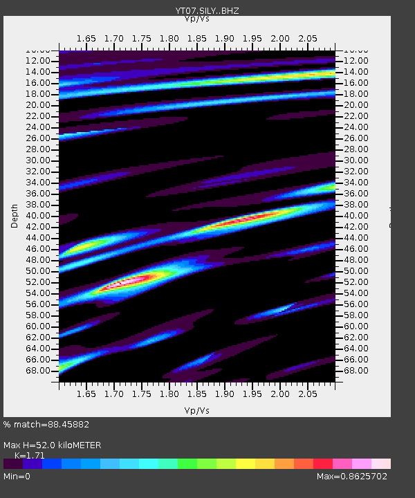
SILY SILY - Earthquake Result Viewer
| Earthquake location: |
South Sandwich Islands Region |
| Earthquake latitude/longitude: |
-57.8/-25.6 |
| Earthquake time(UTC): |
2017/09/04 (247) 08:07:35 GMT |
| Earthquake Depth: |
35 km |
| Earthquake Magnitude: |
6.0 Mww |
| Earthquake Catalog/Contributor: |
NEIC PDE/us |
|
| Network: |
YT POLENET |
| Station: |
SILY SILY |
| Lat/Lon: |
77.13 S/125.97 W |
| Elevation: |
2093 m |
|
| Distance: |
36.7 deg |
| Az: |
201.623 deg |
| Baz: |
118.275 deg |
| Ray Param: |
0.07644843 |
| Estimated Moho Depth: |
52.0 km |
| Estimated Crust Vp/Vs: |
1.71 |
| Assumed Crust Vp: |
6.138 km/s |
| Estimated Crust Vs: |
3.589 km/s |
| Estimated Crust Poisson's Ratio: |
0.24 |
|
| Radial Match: |
88.45882 % |
| Radial Bump: |
400 |
| Transverse Match: |
67.8357 % |
| Transverse Bump: |
400 |
| SOD ConfigId: |
13570011 |
| Insert Time: |
2019-04-28 16:47:18.513 +0000 |
| GWidth: |
2.5 |
| Max Bumps: |
400 |
| Tol: |
0.001 |
|

Signal To Noise
| Channel | StoN | STA | LTA |
| YT:SILY: :BHZ:20170904T08:14:08.999995Z | 7.14989 | 1.531121E-6 | 2.141461E-7 |
| YT:SILY: :BHN:20170904T08:14:08.999995Z | 1.9313467 | 5.2030515E-7 | 2.6940018E-7 |
| YT:SILY: :BHE:20170904T08:14:08.999995Z | 2.8591464 | 6.94055E-7 | 2.4274902E-7 |
| Arrivals |
| Ps | 6.4 SECOND |
| PpPs | 21 SECOND |
| PsPs/PpSs | 28 SECOND |


