You are here: Home > Network List > GS - US Geological Survey Networks Stations List
> Station DEC08 Decatur Surface Seismic Site, Decatur, IL, USA > Earthquake Result Viewer
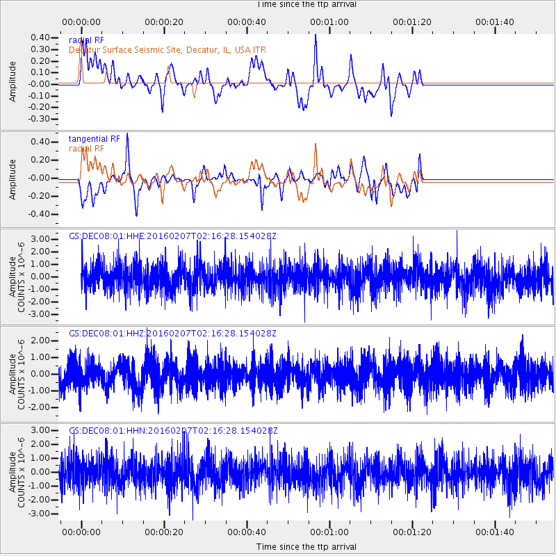
DEC08 Decatur Surface Seismic Site, Decatur, IL, USA - Earthquake Result Viewer
*The percent match for this event was below the threshold and hence no stack was calculated.
| Earthquake location: |
Tonga Islands |
| Earthquake latitude/longitude: |
-15.2/-173.4 |
| Earthquake time(UTC): |
2016/02/07 (038) 02:03:40 GMT |
| Earthquake Depth: |
51 km |
| Earthquake Magnitude: |
5.4 MB, 5.8 MWB, 5.9 MWW, 6.0 MWC |
| Earthquake Catalog/Contributor: |
NEIC PDE/NEIC COMCAT |
|
| Network: |
GS US Geological Survey Networks |
| Station: |
DEC08 Decatur Surface Seismic Site, Decatur, IL, USA |
| Lat/Lon: |
39.86 N/88.92 W |
| Elevation: |
210 m |
|
| Distance: |
95.4 deg |
| Az: |
50.319 deg |
| Baz: |
254.854 deg |
| Ray Param: |
$rayparam |
*The percent match for this event was below the threshold and hence was not used in the summary stack. |
|
| Radial Match: |
59.18544 % |
| Radial Bump: |
400 |
| Transverse Match: |
60.783028 % |
| Transverse Bump: |
400 |
| SOD ConfigId: |
1427151 |
| Insert Time: |
2016-02-21 02:59:20.010 +0000 |
| GWidth: |
2.5 |
| Max Bumps: |
400 |
| Tol: |
0.001 |
|
Signal To Noise
| Channel | StoN | STA | LTA |
| GS:DEC08:01:HHZ:20160207T02:16:28.154028Z | 0.7873818 | 7.096501E-7 | 9.0127827E-7 |
| GS:DEC08:01:HHN:20160207T02:16:28.154028Z | 0.8981454 | 8.9899237E-7 | 1.000943E-6 |
| GS:DEC08:01:HHE:20160207T02:16:28.154028Z | 0.82664293 | 8.5244375E-7 | 1.0312116E-6 |
| Arrivals |
| Ps | |
| PpPs | |
| PsPs/PpSs | |


