You are here: Home > Network List > GS - US Geological Survey Networks Stations List
> Station KAN10 Keim Farm, Anthony, KS, USA > Earthquake Result Viewer
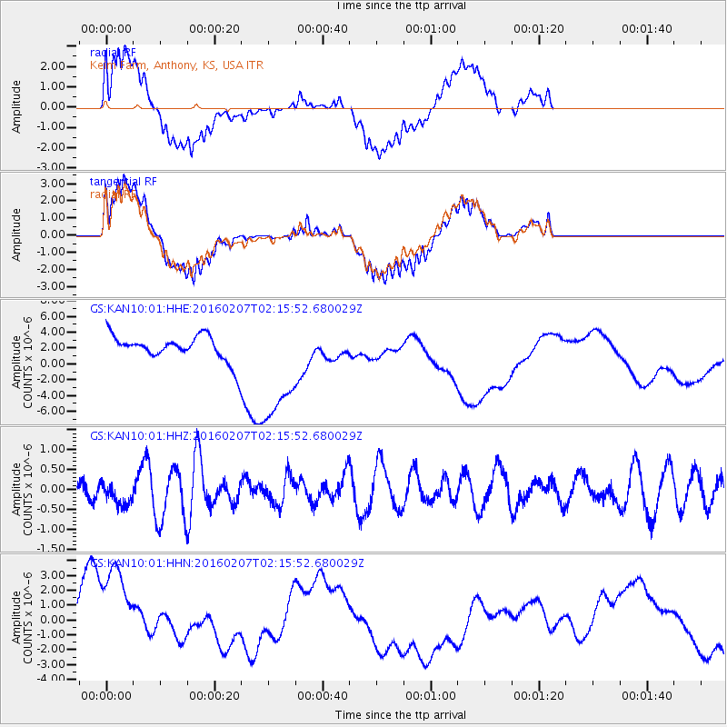
KAN10 Keim Farm, Anthony, KS, USA - Earthquake Result Viewer
*The percent match for this event was below the threshold and hence no stack was calculated.
| Earthquake location: |
Tonga Islands |
| Earthquake latitude/longitude: |
-15.2/-173.4 |
| Earthquake time(UTC): |
2016/02/07 (038) 02:03:40 GMT |
| Earthquake Depth: |
51 km |
| Earthquake Magnitude: |
5.4 MB, 5.8 MWB, 5.9 MWW, 6.0 MWC |
| Earthquake Catalog/Contributor: |
NEIC PDE/NEIC COMCAT |
|
| Network: |
GS US Geological Survey Networks |
| Station: |
KAN10 Keim Farm, Anthony, KS, USA |
| Lat/Lon: |
37.12 N/98.10 W |
| Elevation: |
417 m |
|
| Distance: |
87.8 deg |
| Az: |
50.69 deg |
| Baz: |
249.151 deg |
| Ray Param: |
$rayparam |
*The percent match for this event was below the threshold and hence was not used in the summary stack. |
|
| Radial Match: |
55.029808 % |
| Radial Bump: |
400 |
| Transverse Match: |
52.661446 % |
| Transverse Bump: |
400 |
| SOD ConfigId: |
1427151 |
| Insert Time: |
2016-02-21 02:59:30.924 +0000 |
| GWidth: |
2.5 |
| Max Bumps: |
400 |
| Tol: |
0.001 |
|
Signal To Noise
| Channel | StoN | STA | LTA |
| GS:KAN10:01:HHZ:20160207T02:15:52.680029Z | 0.9823432 | 2.8755196E-7 | 2.9272047E-7 |
| GS:KAN10:01:HHN:20160207T02:15:52.680029Z | 3.9243672 | 4.12688E-6 | 1.0516039E-6 |
| GS:KAN10:01:HHE:20160207T02:15:52.680029Z | 4.5996366 | 7.343537E-6 | 1.5965473E-6 |
| Arrivals |
| Ps | |
| PpPs | |
| PsPs/PpSs | |


