You are here: Home > Network List > II - Global Seismograph Network (GSN - IRIS/IDA) Stations List
> Station WRAB Tennant Creek, NT, Australia > Earthquake Result Viewer
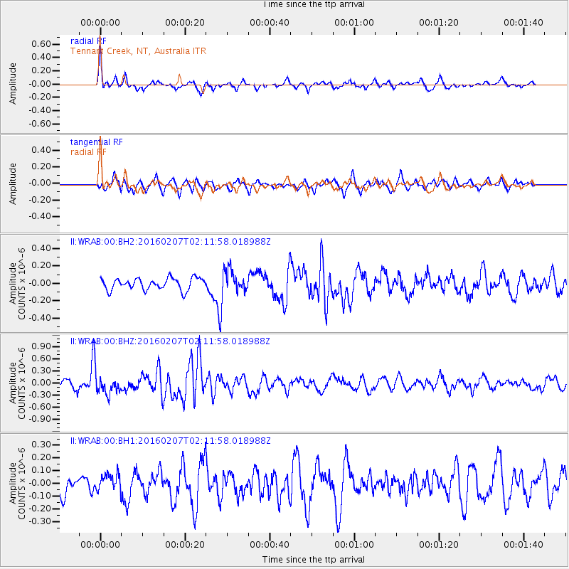
WRAB Tennant Creek, NT, Australia - Earthquake Result Viewer
*The percent match for this event was below the threshold and hence no stack was calculated.
| Earthquake location: |
Tonga Islands |
| Earthquake latitude/longitude: |
-15.2/-173.4 |
| Earthquake time(UTC): |
2016/02/07 (038) 02:03:40 GMT |
| Earthquake Depth: |
51 km |
| Earthquake Magnitude: |
5.4 MB, 5.8 MWB, 5.9 MWW, 6.0 MWC |
| Earthquake Catalog/Contributor: |
NEIC PDE/NEIC COMCAT |
|
| Network: |
II Global Seismograph Network (GSN - IRIS/IDA) |
| Station: |
WRAB Tennant Creek, NT, Australia |
| Lat/Lon: |
19.93 S/134.36 E |
| Elevation: |
366 m |
|
| Distance: |
49.9 deg |
| Az: |
256.62 deg |
| Baz: |
93.377 deg |
| Ray Param: |
$rayparam |
*The percent match for this event was below the threshold and hence was not used in the summary stack. |
|
| Radial Match: |
63.95263 % |
| Radial Bump: |
311 |
| Transverse Match: |
58.191986 % |
| Transverse Bump: |
400 |
| SOD ConfigId: |
1427151 |
| Insert Time: |
2016-02-21 03:00:25.740 +0000 |
| GWidth: |
2.5 |
| Max Bumps: |
400 |
| Tol: |
0.001 |
|
Signal To Noise
| Channel | StoN | STA | LTA |
| II:WRAB:00:BHZ:20160207T02:11:58.018988Z | 2.028601 | 1.9408306E-7 | 9.567336E-8 |
| II:WRAB:00:BH1:20160207T02:11:58.018988Z | 0.6774506 | 6.686602E-8 | 9.870243E-8 |
| II:WRAB:00:BH2:20160207T02:11:58.018988Z | 1.8355259 | 1.2305345E-7 | 6.703989E-8 |
| Arrivals |
| Ps | |
| PpPs | |
| PsPs/PpSs | |


