You are here: Home > Network List > TA - USArray Transportable Network (new EarthScope stations) Stations List
> Station 435B Jarrell, TX, USA > Earthquake Result Viewer
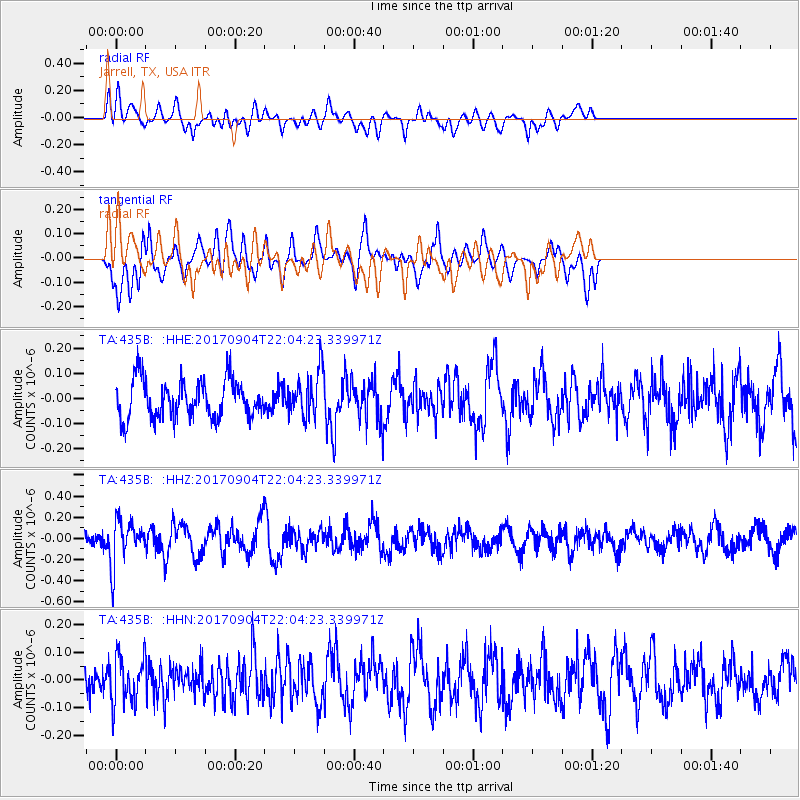
435B Jarrell, TX, USA - Earthquake Result Viewer
*The percent match for this event was below the threshold and hence no stack was calculated.
| Earthquake location: |
Near Coast Of Northern Chile |
| Earthquake latitude/longitude: |
-19.3/-70.0 |
| Earthquake time(UTC): |
2017/09/04 (247) 21:55:20 GMT |
| Earthquake Depth: |
63 km |
| Earthquake Magnitude: |
5.1 Mwr |
| Earthquake Catalog/Contributor: |
NEIC PDE/us |
|
| Network: |
TA USArray Transportable Network (new EarthScope stations) |
| Station: |
435B Jarrell, TX, USA |
| Lat/Lon: |
30.78 N/97.58 W |
| Elevation: |
248 m |
|
| Distance: |
56.4 deg |
| Az: |
331.45 deg |
| Baz: |
148.365 deg |
| Ray Param: |
$rayparam |
*The percent match for this event was below the threshold and hence was not used in the summary stack. |
|
| Radial Match: |
62.320885 % |
| Radial Bump: |
400 |
| Transverse Match: |
50.70731 % |
| Transverse Bump: |
400 |
| SOD ConfigId: |
13570011 |
| Insert Time: |
2019-04-28 16:53:40.869 +0000 |
| GWidth: |
2.5 |
| Max Bumps: |
400 |
| Tol: |
0.001 |
|
Signal To Noise
| Channel | StoN | STA | LTA |
| TA:435B: :HHZ:20170904T22:04:23.339971Z | 1.9962708 | 2.1380708E-7 | 1.0710325E-7 |
| TA:435B: :HHN:20170904T22:04:23.339971Z | 1.5385516 | 8.719435E-8 | 5.667301E-8 |
| TA:435B: :HHE:20170904T22:04:23.339971Z | 1.3229274 | 9.850446E-8 | 7.4459464E-8 |
| Arrivals |
| Ps | |
| PpPs | |
| PsPs/PpSs | |


