You are here: Home > Network List > TA - USArray Transportable Network (new EarthScope stations) Stations List
> Station T25A Trinidad, CO, USA > Earthquake Result Viewer
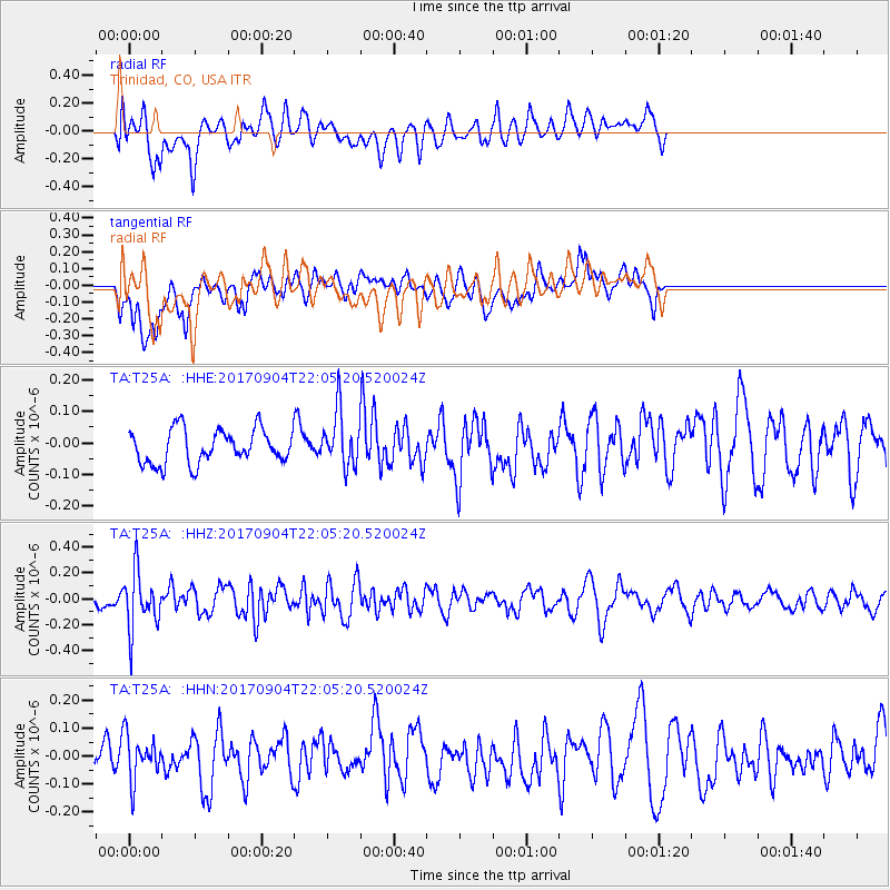
T25A Trinidad, CO, USA - Earthquake Result Viewer
*The percent match for this event was below the threshold and hence no stack was calculated.
| Earthquake location: |
Near Coast Of Northern Chile |
| Earthquake latitude/longitude: |
-19.3/-70.0 |
| Earthquake time(UTC): |
2017/09/04 (247) 21:55:20 GMT |
| Earthquake Depth: |
63 km |
| Earthquake Magnitude: |
5.1 Mwr |
| Earthquake Catalog/Contributor: |
NEIC PDE/us |
|
| Network: |
TA USArray Transportable Network (new EarthScope stations) |
| Station: |
T25A Trinidad, CO, USA |
| Lat/Lon: |
37.14 N/104.41 W |
| Elevation: |
2017 m |
|
| Distance: |
64.8 deg |
| Az: |
330.093 deg |
| Baz: |
143.893 deg |
| Ray Param: |
$rayparam |
*The percent match for this event was below the threshold and hence was not used in the summary stack. |
|
| Radial Match: |
59.42725 % |
| Radial Bump: |
400 |
| Transverse Match: |
62.80323 % |
| Transverse Bump: |
400 |
| SOD ConfigId: |
13570011 |
| Insert Time: |
2019-04-28 16:53:57.244 +0000 |
| GWidth: |
2.5 |
| Max Bumps: |
400 |
| Tol: |
0.001 |
|
Signal To Noise
| Channel | StoN | STA | LTA |
| TA:T25A: :HHZ:20170904T22:05:20.520024Z | 3.663959 | 2.223448E-7 | 6.06843E-8 |
| TA:T25A: :HHN:20170904T22:05:20.520024Z | 1.2571874 | 8.1916355E-8 | 6.515843E-8 |
| TA:T25A: :HHE:20170904T22:05:20.520024Z | 1.880943 | 1.0853195E-7 | 5.7700817E-8 |
| Arrivals |
| Ps | |
| PpPs | |
| PsPs/PpSs | |


