You are here: Home > Network List > TA - USArray Transportable Network (new EarthScope stations) Stations List
> Station J23A Dilts Ranch, Bill, WY, USA > Earthquake Result Viewer
J23A Dilts Ranch, Bill, WY, USA - Earthquake Result Viewer
| Earthquake location: |
Near S. Coast Of Honshu, Japan |
| Earthquake latitude/longitude: |
33.2/137.9 |
| Earthquake time(UTC): |
2009/08/09 (221) 10:55:55 GMT |
| Earthquake Depth: |
297 km |
| Earthquake Magnitude: |
6.5 MB, 7.1 MW, 7.1 MW |
| Earthquake Catalog/Contributor: |
WHDF/NEIC |
|
| Network: |
TA USArray Transportable Network (new EarthScope stations) |
| Station: |
J23A Dilts Ranch, Bill, WY, USA |
| Lat/Lon: |
43.40 N/105.55 W |
| Elevation: |
1499 m |
|
| Distance: |
84.3 deg |
| Az: |
40.958 deg |
| Baz: |
311.03 deg |
| Ray Param: |
0.044849794 |
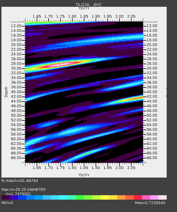
| Estimated Moho Depth: |
28.25 km |
| Estimated Crust Vp/Vs: |
1.75 |
| Assumed Crust Vp: |
6.159 km/s |
| Estimated Crust Vs: |
3.524 km/s |
| Estimated Crust Poisson's Ratio: |
0.26 |
|
| Radial Match: |
81.66764 % |
| Radial Bump: |
400 |
| Transverse Match: |
74.33141 % |
| Transverse Bump: |
400 |
| SOD ConfigId: |
2622 |
| Insert Time: |
2010-03-06 03:20:42.676 +0000 |
| GWidth: |
2.5 |
| Max Bumps: |
400 |
| Tol: |
0.001 |
|
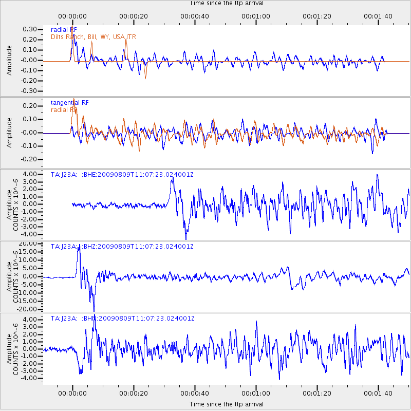
Signal To Noise
| Channel | StoN | STA | LTA |
| TA:J23A: :BHZ:20090809T11:07:23.024001Z | 48.4741 | 7.813387E-6 | 1.6118685E-7 |
| TA:J23A: :BHN:20090809T11:07:23.024001Z | 8.790049 | 1.6477319E-6 | 1.8745423E-7 |
| TA:J23A: :BHE:20090809T11:07:23.024001Z | 8.66649 | 1.6476556E-6 | 1.90118E-7 |
| Arrivals |
| Ps | 3.5 SECOND |
| PpPs | 12 SECOND |
| PsPs/PpSs | 16 SECOND |


