You are here: Home > Network List > TA - USArray Transportable Network (new EarthScope stations) Stations List
> Station J23A Dilts Ranch, Bill, WY, USA > Earthquake Result Viewer
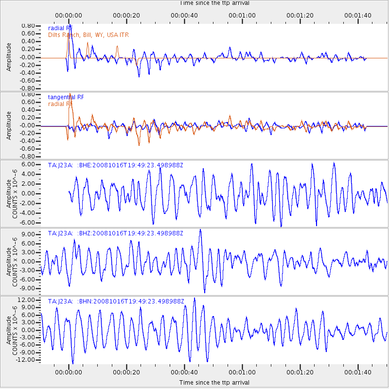
J23A Dilts Ranch, Bill, WY, USA - Earthquake Result Viewer
*The percent match for this event was below the threshold and hence no stack was calculated.
| Earthquake location: |
Near Coast Of Chiapas, Mexico |
| Earthquake latitude/longitude: |
14.3/-92.6 |
| Earthquake time(UTC): |
2008/10/16 (290) 19:43:37 GMT |
| Earthquake Depth: |
23 km |
| Earthquake Magnitude: |
5.8 MB |
| Earthquake Catalog/Contributor: |
WHDF/NEIC |
|
| Network: |
TA USArray Transportable Network (new EarthScope stations) |
| Station: |
J23A Dilts Ranch, Bill, WY, USA |
| Lat/Lon: |
43.40 N/105.55 W |
| Elevation: |
1499 m |
|
| Distance: |
31.1 deg |
| Az: |
341.506 deg |
| Baz: |
155.039 deg |
| Ray Param: |
$rayparam |
*The percent match for this event was below the threshold and hence was not used in the summary stack. |
|
| Radial Match: |
78.202576 % |
| Radial Bump: |
400 |
| Transverse Match: |
71.26345 % |
| Transverse Bump: |
400 |
| SOD ConfigId: |
2556 |
| Insert Time: |
2010-03-06 03:21:09.004 +0000 |
| GWidth: |
2.5 |
| Max Bumps: |
400 |
| Tol: |
0.001 |
|
Signal To Noise
| Channel | StoN | STA | LTA |
| TA:J23A: :BHZ:20081016T19:49:23.498988Z | 1.6520733 | 4.520509E-6 | 2.7362642E-6 |
| TA:J23A: :BHN:20081016T19:49:23.498988Z | 1.9910113 | 6.4253773E-6 | 3.227193E-6 |
| TA:J23A: :BHE:20081016T19:49:23.498988Z | 1.8172364 | 3.4367963E-6 | 1.8912212E-6 |
| Arrivals |
| Ps | |
| PpPs | |
| PsPs/PpSs | |


