You are here: Home > Network List > II - Global Seismograph Network (GSN - IRIS/IDA) Stations List
> Station WRAB Tennant Creek, NT, Australia > Earthquake Result Viewer
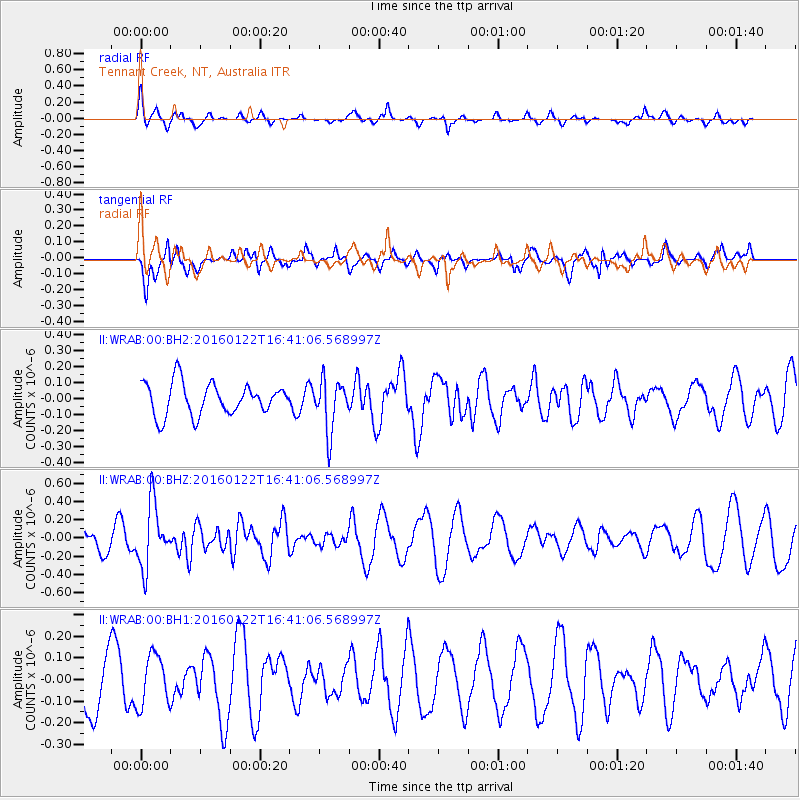
WRAB Tennant Creek, NT, Australia - Earthquake Result Viewer
*The percent match for this event was below the threshold and hence no stack was calculated.
| Earthquake location: |
Vanuatu Islands Region |
| Earthquake latitude/longitude: |
-13.7/172.1 |
| Earthquake time(UTC): |
2016/01/22 (022) 16:34:35 GMT |
| Earthquake Depth: |
44 km |
| Earthquake Magnitude: |
5.6 MWW, 5.5 MWC |
| Earthquake Catalog/Contributor: |
NEIC PDE/NEIC COMCAT |
|
| Network: |
II Global Seismograph Network (GSN - IRIS/IDA) |
| Station: |
WRAB Tennant Creek, NT, Australia |
| Lat/Lon: |
19.93 S/134.36 E |
| Elevation: |
366 m |
|
| Distance: |
36.6 deg |
| Az: |
255.023 deg |
| Baz: |
86.259 deg |
| Ray Param: |
$rayparam |
*The percent match for this event was below the threshold and hence was not used in the summary stack. |
|
| Radial Match: |
63.46878 % |
| Radial Bump: |
335 |
| Transverse Match: |
44.57991 % |
| Transverse Bump: |
377 |
| SOD ConfigId: |
1427151 |
| Insert Time: |
2016-02-21 08:54:47.950 +0000 |
| GWidth: |
2.5 |
| Max Bumps: |
400 |
| Tol: |
0.001 |
|
Signal To Noise
| Channel | StoN | STA | LTA |
| II:WRAB:00:BHZ:20160122T16:41:06.568997Z | 2.8711743 | 3.499241E-7 | 1.218749E-7 |
| II:WRAB:00:BH1:20160122T16:41:06.568997Z | 0.78805214 | 1.1731498E-7 | 1.4886703E-7 |
| II:WRAB:00:BH2:20160122T16:41:06.568997Z | 1.5956584 | 1.5910422E-7 | 9.97107E-8 |
| Arrivals |
| Ps | |
| PpPs | |
| PsPs/PpSs | |


