You are here: Home > Network List > TA - USArray Transportable Network (new EarthScope stations) Stations List
> Station J26L Joseph Creek, AK, USA > Earthquake Result Viewer
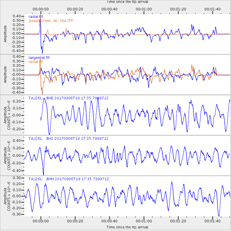
J26L Joseph Creek, AK, USA - Earthquake Result Viewer
*The percent match for this event was below the threshold and hence no stack was calculated.
| Earthquake location: |
Tonga Islands |
| Earthquake latitude/longitude: |
-15.4/-173.6 |
| Earthquake time(UTC): |
2017/09/06 (249) 19:05:48 GMT |
| Earthquake Depth: |
56 km |
| Earthquake Magnitude: |
5.1 mb |
| Earthquake Catalog/Contributor: |
NEIC PDE/us |
|
| Network: |
TA USArray Transportable Network (new EarthScope stations) |
| Station: |
J26L Joseph Creek, AK, USA |
| Lat/Lon: |
64.50 N/143.56 W |
| Elevation: |
1144 m |
|
| Distance: |
82.9 deg |
| Az: |
12.63 deg |
| Baz: |
209.16 deg |
| Ray Param: |
$rayparam |
*The percent match for this event was below the threshold and hence was not used in the summary stack. |
|
| Radial Match: |
65.142365 % |
| Radial Bump: |
400 |
| Transverse Match: |
51.018436 % |
| Transverse Bump: |
400 |
| SOD ConfigId: |
13570011 |
| Insert Time: |
2019-04-28 17:06:13.763 +0000 |
| GWidth: |
2.5 |
| Max Bumps: |
400 |
| Tol: |
0.001 |
|
Signal To Noise
| Channel | StoN | STA | LTA |
| TA:J26L: :BHZ:20170906T19:17:35.799971Z | 2.4380584 | 1.9957525E-7 | 8.185828E-8 |
| TA:J26L: :BHN:20170906T19:17:35.799971Z | 1.579942 | 1.3364107E-7 | 8.458606E-8 |
| TA:J26L: :BHE:20170906T19:17:35.799971Z | 1.3421559 | 1.468116E-7 | 1.0938491E-7 |
| Arrivals |
| Ps | |
| PpPs | |
| PsPs/PpSs | |


