You are here: Home > Network List > AV - Alaska Volcano Observatory Stations List
> Station SPCR Ckakachatna River, Mount Spurr, Alaska > Earthquake Result Viewer
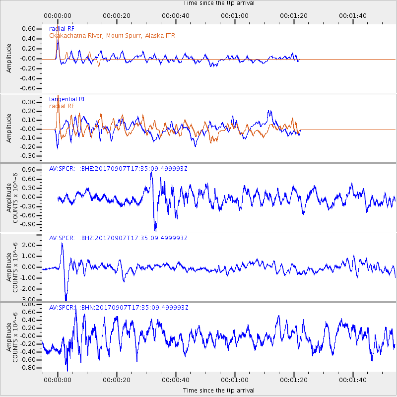
SPCR Ckakachatna River, Mount Spurr, Alaska - Earthquake Result Viewer
*The percent match for this event was below the threshold and hence no stack was calculated.
| Earthquake location: |
Bonin Islands, Japan Region |
| Earthquake latitude/longitude: |
27.8/139.8 |
| Earthquake time(UTC): |
2017/09/07 (250) 17:26:49 GMT |
| Earthquake Depth: |
448 km |
| Earthquake Magnitude: |
6.1 Mww |
| Earthquake Catalog/Contributor: |
NEIC PDE/us |
|
| Network: |
AV Alaska Volcano Observatory |
| Station: |
SPCR Ckakachatna River, Mount Spurr, Alaska |
| Lat/Lon: |
61.20 N/152.21 W |
| Elevation: |
984 m |
|
| Distance: |
55.5 deg |
| Az: |
33.002 deg |
| Baz: |
265.385 deg |
| Ray Param: |
$rayparam |
*The percent match for this event was below the threshold and hence was not used in the summary stack. |
|
| Radial Match: |
73.366486 % |
| Radial Bump: |
400 |
| Transverse Match: |
65.84882 % |
| Transverse Bump: |
344 |
| SOD ConfigId: |
13570011 |
| Insert Time: |
2019-04-28 17:10:03.745 +0000 |
| GWidth: |
2.5 |
| Max Bumps: |
400 |
| Tol: |
0.001 |
|
Signal To Noise
| Channel | StoN | STA | LTA |
| AV:SPCR: :BHZ:20170907T17:35:09.499993Z | 8.72825 | 1.3421914E-6 | 1.5377556E-7 |
| AV:SPCR: :BHN:20170907T17:35:09.499993Z | 2.3205862 | 4.455189E-7 | 1.9198549E-7 |
| AV:SPCR: :BHE:20170907T17:35:09.499993Z | 4.2978277 | 5.5851865E-7 | 1.299537E-7 |
| Arrivals |
| Ps | |
| PpPs | |
| PsPs/PpSs | |


