You are here: Home > Network List > TA - USArray Transportable Network (new EarthScope stations) Stations List
> Station P17A Butcher Ranch, Price, UT, USA > Earthquake Result Viewer
P17A Butcher Ranch, Price, UT, USA - Earthquake Result Viewer
| Earthquake location: |
Off East Coast Of Honshu, Japan |
| Earthquake latitude/longitude: |
37.6/142.2 |
| Earthquake time(UTC): |
2008/07/19 (201) 02:39:28 GMT |
| Earthquake Depth: |
22 km |
| Earthquake Magnitude: |
6.2 MB, 7.0 MS, 7.0 MW, 6.9 MW |
| Earthquake Catalog/Contributor: |
WHDF/NEIC |
|
| Network: |
TA USArray Transportable Network (new EarthScope stations) |
| Station: |
P17A Butcher Ranch, Price, UT, USA |
| Lat/Lon: |
39.47 N/110.74 W |
| Elevation: |
1687 m |
|
| Distance: |
78.2 deg |
| Az: |
49.104 deg |
| Baz: |
309.089 deg |
| Ray Param: |
0.049758896 |
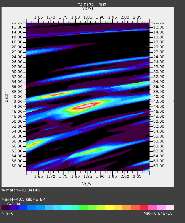
| Estimated Moho Depth: |
43.5 km |
| Estimated Crust Vp/Vs: |
1.84 |
| Assumed Crust Vp: |
6.207 km/s |
| Estimated Crust Vs: |
3.373 km/s |
| Estimated Crust Poisson's Ratio: |
0.29 |
|
| Radial Match: |
96.84146 % |
| Radial Bump: |
345 |
| Transverse Match: |
81.281944 % |
| Transverse Bump: |
400 |
| SOD ConfigId: |
2504 |
| Insert Time: |
2010-03-06 03:22:55.225 +0000 |
| GWidth: |
2.5 |
| Max Bumps: |
400 |
| Tol: |
0.001 |
|

Signal To Noise
| Channel | StoN | STA | LTA |
| TA:P17A: :BHZ:20080719T02:50:55.249011Z | 3.8343883 | 5.4969234E-7 | 1.4335855E-7 |
| TA:P17A: :BHN:20080719T02:50:55.249011Z | 1.3337541 | 1.6331583E-7 | 1.2244824E-7 |
| TA:P17A: :BHE:20080719T02:50:55.249011Z | 2.4409056 | 1.6776812E-7 | 6.8731914E-8 |
| Arrivals |
| Ps | 6.0 SECOND |
| PpPs | 19 SECOND |
| PsPs/PpSs | 25 SECOND |


